1900s (20th Century) Maps of Summertown, California
Explore 11 historic maps of Summertown from the 1900s (20th Century). These maps offer a rare glimpse into what life looked like during the 1900s — showing old roads, neighborhoods, homes, and landmarks that have changed or disappeared over time.
Whether you're researching your family's past, planning a metal detecting trip, or studying how Summertown's landscape evolved across the 1900s, these high-resolution maps are a powerful tool for exploring the history of this region.
- Focus on a specific era: All maps on this page are from the 1900s, giving you a focused view of this time period.
- See what’s changed: Compare century-old streets, trails, and buildings to today's modern landscape using overlays and satellite layers.
- Research with precision: Use these maps for genealogy, historical research, land use analysis, or educational projects.
- View, download, or print: Maps are fully viewable online in high resolution, and can be downloaded or printed for your own records.
Start exploring Summertown's history through authentic maps from the 1900s. This is your window into the past.
Summertown, CA maps
(11)- 1935 Map of Burney
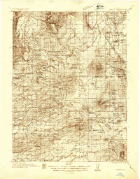 1935 Burney1935 Print · USGSShasta County's high country is captured in the mid-1930s, showing a transition from ranching to early hydroelectric power. Trace family ranch sites like Armstrong Ranch and long-lost rural schools including Mill Creek Sch and Mountain Grove Sch.2 unique versions available
 - 1939 Map of Burney
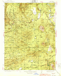 1939 Burney1939 Print · USGSShasta County mountain life is captured here in the late 1930s, from the volcanic peaks of the Cascades to the timbered ridges above the Pit River. Genealogists can locate family-named landmarks and remote outposts like Montgomery Creek, Doyles Corner, and the Old Mill Site.3 unique versions available
 - 1955 Map of Westwood, 1959 Print
 1955 Westwood1959 Print · USGSIn the mid-fifties, the northeastern California interior supported a landscape of mountain timber and high-desert basins. Genealogists and historians can locate early settlements and industrial sites like Susanville, Herlong, and the Sierra Ordinance Depot.
 - 1956 Map of Manzanita Lake, 1958 Print
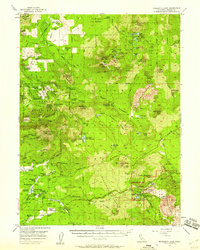 1956 Manzanita Lake1958 Print · USGSShasta County saw a shift toward recreation and forest management in the 1950s as mountain ranching remained a vital local fixture. Researchers can locate family landmarks like Farnsworth Ranch, the settlement of Viola, and historical routes like the Old Emigrant Trail.3 unique versions available
 - 1958 Map of Westwood
 1958 Westwood1958 Print · USGSNorthern California in the late fifties shows a landscape of volcanic peaks and rising reservoirs. Researchers can locate the Sierra Ordinance Depot and trace mountain infrastructure through the Hat Creek Ranger Station and Stacy Siding.
 - 1959 Map of Westwood
 1959 Westwood1959 Print · USGSNortheastern California during the late 1950s was a hub of timber, military logistics, and mountain railroading. Researchers can trace the path of the Southern Pacific through the Honey Lake Valley and locate landmarks like the Sierra Ordinance Depot and Lassen Peak.
 - 1962 Map of Susanville, 1965 Print
 1962 Susanville1965 Print · USGSNortheastern California's high desert and volcanic peaks meet in the early sixties, showing the region's timber and rail hubs in transition. Local historians can trace the Southern Pacific lines through Susanville and Litchfield, or explore the sprawling Sierra Army Depot and Lassen Volcanic National Park.2 unique versions available
 - 1968 Map of Susanville
 1968 Susanville1968 Print · USGSThe high Sierras and the Great Basin collide in the late 1960s, showing a landscape of volcanic peaks, timber settlements, and desert plains. Genealogists and researchers can trace historic rail lines like the Western Pacific or locate residents in Susanville, Westwood, and Janesville.
 - 1976 Map of Burney, 1992 Print
 1976 Burney1992 Print · USGSShasta and Lassen counties come alive in the mid-seventies, documenting a rugged landscape of volcanic peaks and timbered wilderness. Genealogists and hikers can trace the Pacific Crest Trail, early ranger outposts like Poison Station, and tribal lands at Montgomery Creek Indian Rancheria.3 unique versions available
 - 1985 Map of Manzanita Lake
 1985 Manzanita Lake1985 Print · USGSShasta County's volcanic highlands are captured here in the mid-1980s, centered on the entrance to the national park. Researchers can trace landforms like Chaos Crater and Chaos Crags or locate recreational sites at Eskimo Hill and Reflection Lake.2 unique versions available
 - 1995 Map of Manzanita Lake, 1997 Print
 1995 Manzanita Lake1997 Print · USGSNorthern California’s volcanic terrain is captured here in the mid-nineties, showing the junction of the national park and forest. Trace the geological formations of Chaos Jumbles or locate historical infrastructure like the Abandoned Flume and Cinder Pits.
End of results
Showing maps 1-11 of 11
Top cities near Summertown
Frequently asked questions
- What are the different types of historical maps available for Summertown?
- What is the oldest map of Summertown?
- Where can I purchase historical maps of Summertown for my home or office?
- Where can I download high-res historical maps of Summertown?
- Are there historical topographic maps available for Summertown?
- Is there historical aerial imagery available for Summertown?
- Where are historical maps of Summertown sourced from?