Old Maps of Sierra County, California
Explore 229 old maps of Sierra County, spanning from 1888 to today. These high-resolution historic maps reveal how streets, neighborhoods, landmarks, and natural features evolved over time — perfect for genealogy, metal detecting, research, and local history exploration.
What you can do with these maps:
- See how Sierra County changed over time: Compare historical maps to modern-day views to trace roads, homesites, rail lines & more.
- View detailed metadata: Each map includes creators, publishers, year, scale, and archive source.
- Overlay maps with satellite & LiDAR: Visualize the past alongside modern tools to explore terrain & human change.
- Trusted historical sources: Maps sourced from the USGS, Library of Congress, and other archives.
- Access maps your way: View online, download high-res files, or order prints for personal or research use.
Start exploring old maps of Sierra County to uncover forgotten places, hidden landmarks, and the deep history beneath your feet.
Sierra County, CA maps
(229)- 1888 Map of Smartsville
 1888 Smartsville1888 Print · USGSGold Country was in its industrial prime during the late eighteen-hundreds, with deep-shaft mines and hydraulic camps dotting the Sierra foothills. Researchers can trace early family holdings and mining claims through landmarks like French Corral, the North Star Mine, and the historic settlement of Timbuctoo.
 - 1888 Map of Bidwell Bar, 1956 Print
 1888 Bidwell Bar1956 Print · USGSThe northern Sierra foothills and Feather River canyons come alive in the late nineteenth century before modern reservoirs altered the landscape. Genealogists and researchers can trace family-named sites like Fields Ranch, Spanish Ranch, and Snows Mine.
 - 1890 Map of Sierraville, 1955 Print
 1890 Sierraville1955 Print · USGSThe high Sierra Valley and its frontier timber towns are captured here in the late 1800s. Genealogists and historians can trace early rail lines like the Nevada California and Oregon Railway and locate vanished stops and landmarks such as Etta, Purdy, and the Sulphur Spring.
 - 1891 Map of Bidwell Bar
 1891 Bidwell Bar1891 Print · USGSThe gold-country ridges and deep river canyons of the northern Sierras are shown in the late nineteenth century as mining and timber production shaped the land. Researchers can trace early family-named waystations and industrial sites like American House, Bidwell Bar, and Clipper Mill.
 - 1891 Map of Downieville
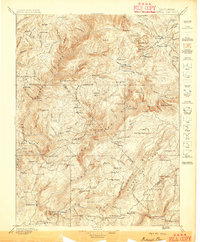
 1891 Downieville1891 Print · USGSThe gold-bearing ridges of the Northern Sierra come alive in the 1890s, when mining camps and high-country ranches defined the local economy. Researchers can trace the Sierra Turnpike and locate historic claims like the Empire Mine or the settlement of Whiskey Diggings.
 - 1891 Map of Colfax
 1891 Colfax1891 Print · USGSThe Sierra Nevada foothills and high ridges of the Gold Country appear in this late nineteenth-century survey during a peak era of mining and rail expansion. Genealogists and historians can trace old hydraulic mining sites like Malakoff and mountain settlements such as North Bloomfield and Gold Run.
 - 1891 Map of Truckee
 1891 Truckee1891 Print · USGSThe High Sierra and Lake Tahoe shoreline are captured here in the late nineteenth century as the railroad transformed the mountain economy. Trace the original path of the Central Pacific Railroad through Donner Pass or locate early lakeside landings at Tahoe City and McKinney.
 - 1891 Map of Smartsville
 1891 Smartsville1891 Print · USGSGold Country in the late nineteenth century was a landscape of deep mines and timber rails. This survey allows researchers to trace the industrial footprint of the Idaho and North Star Mine alongside vanished camps like Condemned Bar and French Corral.
 - 1892 Map of Sierraville
 1892 Sierraville1892 Print · USGSSierraville and the high meadows of the eastern Sierras are shown here in the early 1890s, just as the regional rail network was expanding. Genealogists can trace early homesteads and communities like Loyalton, Sattley, and Beckwith, or follow the California Nevada and Oregon Railway as it winds toward the state line.
 - 1892 Map of Smartsville
 1892 Smartsville1892 Print · USGSThe gold-bearing ridges of the Sierra foothills are captured here in the late nineteenth century, showing the height of the hard-rock mining boom. Researchers can trace the narrow-gauge rail lines and locate famous claims including the Empire Mine, Idaho Mine, and the Sulphuret Works.
 - 1892 Map of Colfax
 1892 Colfax1892 Print · USGSThe Sierra Nevada foothills thrive with mining and rail activity in the 1890s as the gold industry matures. Genealogists and historians can trace old claims and communities like North Bloomfield, Alleghany, and the Alaska Mine along the Central Pacific Railroad.
 - 1893 Map of Bidwell Bar
 1893 Bidwell Bar1893 Print · USGSThe Plumas mountains during the late nineteenth century show a landscape defined by gold-era mining and remote stage stops. Genealogists and historians can locate early homesteads and industrial sites like Snows Mine, American House, and Bidwell Bar.
 - 1893 Map of Truckee
 1893 Truckee1893 Print · USGSHigh Sierra transit and industry dominate this late nineteenth-century landscape as the Central Pacific Railroad crosses the divide. Trace the early footprints of Tahoe City, the remote lodges at Rubicon Springs, and the timber operations around Boca.
 - 1893 Map of Downieville
 1893 Downieville1893 Print · USGSThe northern Sierra Nevada's gold country is revealed here during its late nineteenth-century mining peak. Researchers can trace historic claims and family outposts from Whiskey Diggings and Poker Flat to the Plumas Eureka mine.
 - 1894 Map of Colfax
 1894 Colfax1894 Print · USGSThe northern Sierra Nevada's mining heartland is mapped here during the late nineteenth-century gold boom. Researchers can trace the paths of the Central Pacific Railroad and locate historic claims like the Delhi Mine and Derbec Mine.
 - 1894 Map of Smartsville
 1894 Smartsville1894 Print · USGSIn the mid-1880s, the Sierra foothills around Nevada City and Grass Valley were a hive of mining and ranching activity. Genealogists and historians can trace old homesteads like Lanes Ranch, follow the Nevada Co Narrow Gauge RR, and locate forgotten camps like Rough & Ready.
 - 1894 Map of Sierraville
 1894 Sierraville1894 Print · USGSThe high Sierra and Plumas county borderlands are shown in the late nineteenth century as early settlements began to take root in the basin. Researchers can trace the path of the California Nevada and Oregon Railway and locate historic sites like Sierraville, the Fair Grounds, and Loyalton.9 unique versions available
 - 1895 Map of Bidwell Bar
 1895 Bidwell Bar1895 Print · USGSThe Sierra foothills and high ridges of Northern California are captured here in the late nineteenth century. Genealogists and historians can trace isolated waystations and timber camps like American House, Spanish Ranch, and the Old Defiance Mill.
 - 1895 Map of Smartsville
 1895 Smartsville1895 Print · USGSThe Northern Mother Lode thrives during the peak of industrial quartz mining in the late nineteenth century. Researchers can trace the complex rail and mine networks of Nevada City and Grass Valley, alongside historic outposts like Smartsville and Rough & Ready.6 unique versions available
 - 1895 Map of Downieville
 1895 Downieville1895 Print · USGSThe high Sierra mining districts of the 1890s are captured here during a peak era of resource extraction. Researchers can trace historic gold camps and industrial sites like Whiskey Diggings, the Plumas Eureka mine, and Poker Flat.
 - 1895 Map of Truckee
 1895 Truckee1895 Print · USGSThe high Sierra and Lake Tahoe's western shore are captured in the late 1800s as the railroad fueled new mountain industry. Trace the historic Central Pacific route past Boca or locate early lakeside spots like McKinney and Rubicon Springs.9 unique versions available
 - 1896 Map of Downieville
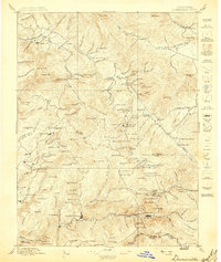
 1896 Downieville1896 Print · USGSThe northern Sierra Nevada comes alive in this 1890s survey of the Feather and Yuba River watersheds. Genealogists and historians can trace gold-rush era settlements from Quincy to Downieville, locating historic sites like Whiskey Diggings and the Empire Mine.
 - 1897 Map of Bidwell Bar
 1897 Bidwell Bar1897 Print · USGSThe Sierra Nevada foothills and river canyons come alive in the 1890s as a landscape of remote mines and mountain ranching. Genealogists can trace early homesteads and social hubs like Spanish Ranch, Forbestown, and Old Defiance Mill.7 unique versions available
 - 1897 Map of Downieville
 1897 Downieville1897 Print · USGSThe northern Sierra Nevada's rugged gold country comes to life in the late nineteenth century, showing the dense network of camps and mines around Downieville. Researchers can trace the exact locations of historic operations like the Young America Mine and long-standing settlements like Howland Flat and Quincy.7 unique versions available
 - 1898 Map of Colfax
 1898 Colfax1898 Print · USGSThe Sierra Nevada gold fields come to life in the late nineteenth century as hydraulic mining reaches its peak. Genealogists and researchers can trace the early industrial footprint of the Malakoff Mine and settlements like Alleghany and North Bloomfield.
Showing maps 1-25 of 229
Top cities of Sierra County
Frequently asked questions
- What are the different types of historical maps available for Sierra County?
- What is the oldest map of Sierra County?
- Where can I purchase historical maps of Sierra County for my home or office?
- Where can I download high-res historical maps of Sierra County?
- Are there historical topographic maps available for Sierra County?
- Is there historical aerial imagery available for Sierra County?
- Where are historical maps of Sierra County sourced from?