1990s Maps of Sierra County, California
Explore 7 historic maps of Sierra County from the 1990s. These maps offer a rare glimpse into what life looked like during the 1990s — showing old roads, neighborhoods, homes, and landmarks that have changed or disappeared over time.
Whether you're researching your family's past, planning a metal detecting trip, or studying how Sierra County's landscape evolved across the 1990s, these high-resolution maps are a powerful tool for exploring the history of this region.
- Focus on a specific era: All maps on this page are from the 1990s, giving you a focused view of this time period.
- See what’s changed: Compare century-old streets, trails, and buildings to today's modern landscape using overlays and satellite layers.
- Research with precision: Use these maps for genealogy, historical research, land use analysis, or educational projects.
- View, download, or print: Maps are fully viewable online in high resolution, and can be downloaded or printed for your own records.
Start exploring Sierra County's history through authentic maps from the 1990s. This is your window into the past.
Sierra County, CA maps
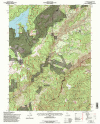
(7)- 1993 Map of Yuba City, 1994 Print
 1993 Yuba City1994 Print · USGSThe Sacramento Valley and Sierra Nevada foothills meet in the 1990s, where agricultural bypasses and river networks surround the iconic Sutter Buttes. Researchers can trace the rail corridors of the Southern Pacific and Western Pacific through hubs like Marysville and Gridley.
 - 1994 Map of American House, 1997 Print
 1994 American House1997 Print · USGSThe Plumas National Forest interior is captured in the mid-1990s as a land of high peaks and historic mining claims. Researchers can trace the heritage of local homesteads and industry through the McIntosh Ranch Cemetery, Boehme Ranch, and the Sunnyside Mine.
 - 1994 Map of La Porte, 1998 Print
 1994 La Porte1998 Print · USGSThe northern Sierra Nevada gold country is mapped here in the mid-1990s, capturing the rugged landscape of the Plumas National Forest. Genealogists can locate old mining settlements like Port Wine, Gibsonville, and Poverty Hill, alongside the Pine Grove Cem.
 - 1994 Map of Onion Valley, 1998 Print
 1994 Onion Valley1998 Print · USGSPlumas National Forest in the mid-1990s reveals a high-country landscape shaped by decades of gold and chrome mining. Researchers can trace the legacy of remote camps and claims at Onion Valley (Site), the White Pine Chrome Mine, and the Barkers Cabin (Site).
 - 1994 Map of Blue Nose Mountain, 1998 Print
 1994 Blue Nose Mountain1998 Print · USGSPlumas and Sierra counties meet in this 1990s survey of the high Sierras, where the river corridor contrasts with soaring ridgelines. Researchers can trace the legacy of gold mining at the Nelson Point (Site) and scattered works like the Carmack Mine.
 - 1994 Map of Strawberry Valley, 1998 Print
 1994 Strawberry Valley1998 Print · USGSThe Sierra Nevada high country near the Yuba and Plumas county line is shown here in the 1990s, where mining history meets modern forestry. Researchers can find old mining sites like Eureka Diggings and Palace Mine alongside the historic Brandy City.
 - 1995 Map of Camptonville
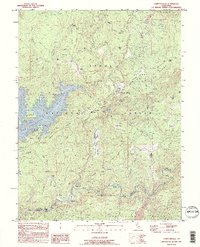 1995 Camptonville1995 Print · USGSSettled among the western Sierra Nevada foothills in the 1990s, this area centers on the historic community of Camptonville. Genealogists and researchers can locate family-named landmarks like Lohman Ranch or Kelly Ranch, and trace the path of the Middle Yuba River past Freemans Crossing.
End of results
Showing maps 1-7 of 7
Top cities of Sierra County
Frequently asked questions
- What are the different types of historical maps available for Sierra County?
- What is the oldest map of Sierra County?
- Where can I purchase historical maps of Sierra County for my home or office?
- Where can I download high-res historical maps of Sierra County?
- Are there historical topographic maps available for Sierra County?
- Is there historical aerial imagery available for Sierra County?
- Where are historical maps of Sierra County sourced from?