1970s Maps of Cecilville, California
Explore 2 historic maps of Cecilville from the 1970s. These maps offer a rare glimpse into what life looked like during the 1970s — showing old roads, neighborhoods, homes, and landmarks that have changed or disappeared over time.
Whether you're researching your family's past, planning a metal detecting trip, or studying how Cecilville's landscape evolved across the 1970s, these high-resolution maps are a powerful tool for exploring the history of this region.
- Focus on a specific era: All maps on this page are from the 1970s, giving you a focused view of this time period.
- See what’s changed: Compare century-old streets, trails, and buildings to today's modern landscape using overlays and satellite layers.
- Research with precision: Use these maps for genealogy, historical research, land use analysis, or educational projects.
- View, download, or print: Maps are fully viewable online in high resolution, and can be downloaded or printed for your own records.
Start exploring Cecilville's history through authentic maps from the 1970s. This is your window into the past.
Cecilville, CA maps
(2)- 1978 Map of Cecilville
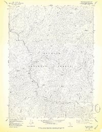 1978 Cecilville1978 Print · USGSThe Salmon River canyon in the late seventies is a rugged landscape of mining claims and remote ranches. Genealogists and historians can trace the foundations of Yoakumville, the King Solomon Mine, and the historic holdings at Godfrey Ranch.
 - 1979 Map of Cecilville
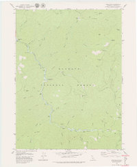 1979 Cecilville1979 Print · USGSSiskiyou County's mountain interior is mapped here in the late seventies, centered on the confluence of the river and Cecil Creek. Local history researchers can trace the locations of the King Solomon Mine, the Yoakumville (Site), and the Crawford Cr FS Station.3 unique versions available
End of results
Showing maps 1-2 of 2
Top cities near Cecilville
Frequently asked questions
- What are the different types of historical maps available for Cecilville?
- What is the oldest map of Cecilville?
- Where can I purchase historical maps of Cecilville for my home or office?
- Where can I download high-res historical maps of Cecilville?
- Are there historical topographic maps available for Cecilville?
- Is there historical aerial imagery available for Cecilville?
- Where are historical maps of Cecilville sourced from?