1980s Maps of Fleener Place, California
Explore 2 historic maps of Fleener Place from the 1980s. These maps offer a rare glimpse into what life looked like during the 1980s — showing old roads, neighborhoods, homes, and landmarks that have changed or disappeared over time.
Whether you're researching your family's past, planning a metal detecting trip, or studying how Fleener Place's landscape evolved across the 1980s, these high-resolution maps are a powerful tool for exploring the history of this region.
- Focus on a specific era: All maps on this page are from the 1980s, giving you a focused view of this time period.
- See what’s changed: Compare century-old streets, trails, and buildings to today's modern landscape using overlays and satellite layers.
- Research with precision: Use these maps for genealogy, historical research, land use analysis, or educational projects.
- View, download, or print: Maps are fully viewable online in high resolution, and can be downloaded or printed for your own records.
Start exploring Fleener Place's history through authentic maps from the 1980s. This is your window into the past.
Fleener Place, CA maps
(2)- 1984 Map of Tulelake, 1985 Print
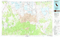 1984 Tulelake1985 Print · USGSThe high desert and volcanic basins of the California-Oregon border are captured here in the mid-eighties. Researchers can trace the legacy of the Southern Pacific railroad through settlements like Stronghold, Newell, and the sprawling Lava Beds National Monument.2 unique versions available
 - 1985 Map of Captain Jacks Stronghold
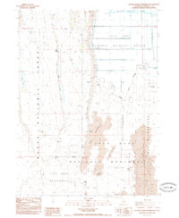 1985 Captain Jacks Stronghold1985 Print · USGSSiskiyou County's volcanic and military history is captured here in the mid-1980s, where the Modoc War's terrain meets reclaimed wetlands. Trace the tactical landscape of Captains Jacks Stronghold and the Site of Thomas & Wright Battle alongside features like Gillem Bluff.
End of results
Showing maps 1-2 of 2
Top cities near Fleener Place
Frequently asked questions
- What are the different types of historical maps available for Fleener Place?
- What is the oldest map of Fleener Place?
- Where can I purchase historical maps of Fleener Place for my home or office?
- Where can I download high-res historical maps of Fleener Place?
- Are there historical topographic maps available for Fleener Place?
- Is there historical aerial imagery available for Fleener Place?
- Where are historical maps of Fleener Place sourced from?