1940s Maps of Lake Shastina, California
Explore 2 historic maps of Lake Shastina from the 1940s. These maps offer a rare glimpse into what life looked like during the 1940s — showing old roads, neighborhoods, homes, and landmarks that have changed or disappeared over time.
Whether you're researching your family's past, planning a metal detecting trip, or studying how Lake Shastina's landscape evolved across the 1940s, these high-resolution maps are a powerful tool for exploring the history of this region.
- Focus on a specific era: All maps on this page are from the 1940s, giving you a focused view of this time period.
- See what’s changed: Compare century-old streets, trails, and buildings to today's modern landscape using overlays and satellite layers.
- Research with precision: Use these maps for genealogy, historical research, land use analysis, or educational projects.
- View, download, or print: Maps are fully viewable online in high resolution, and can be downloaded or printed for your own records.
Start exploring Lake Shastina's history through authentic maps from the 1940s. This is your window into the past.
Lake Shastina, CA maps
(2)- 1941 Map of Macdoel
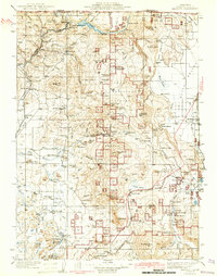 1941 Macdoel1941 Print · USGSUpper Siskiyou County is seen here just before the mid-century, where the timber industry and Southern Pacific rail lines defined the high valley landscape. Genealogists can trace early homesteads like Prather Ranch and Soule Ranch, alongside several local schoolhouses and the State Fish Hatchery.3 unique versions available
 - 1948 Map of Weed, 1950 Print
 1948 Weed1950 Print · USGSNorthern California and Southern Oregon are captured here during the post-war era, documenting the mountain-and-valley economies of the Klamath and Cascade ranges. Trace the legacy of local mining and timber at the King Solomon Mine, find old schools like Siskiyou County School, and follow the historic Southern Pacific RR route.2 unique versions available
End of results
Showing maps 1-2 of 2
Top cities near Lake Shastina
- Yreka historical maps
- Mount Shasta historical maps
- Weed historical maps
- Montague historical maps
- Grenada historical maps
Frequently asked questions
- What are the different types of historical maps available for Lake Shastina?
- What is the oldest map of Lake Shastina?
- Where can I purchase historical maps of Lake Shastina for my home or office?
- Where can I download high-res historical maps of Lake Shastina?
- Are there historical topographic maps available for Lake Shastina?
- Is there historical aerial imagery available for Lake Shastina?
- Where are historical maps of Lake Shastina sourced from?