1990s Maps of Lakin, California
Explore 3 historic maps of Lakin from the 1990s. These maps offer a rare glimpse into what life looked like during the 1990s — showing old roads, neighborhoods, homes, and landmarks that have changed or disappeared over time.
Whether you're researching your family's past, planning a metal detecting trip, or studying how Lakin's landscape evolved across the 1990s, these high-resolution maps are a powerful tool for exploring the history of this region.
- Focus on a specific era: All maps on this page are from the 1990s, giving you a focused view of this time period.
- See what’s changed: Compare century-old streets, trails, and buildings to today's modern landscape using overlays and satellite layers.
- Research with precision: Use these maps for genealogy, historical research, land use analysis, or educational projects.
- View, download, or print: Maps are fully viewable online in high resolution, and can be downloaded or printed for your own records.
Start exploring Lakin's history through authentic maps from the 1990s. This is your window into the past.
Lakin, CA maps
(3)- 1990 Map of Porcupine Butte
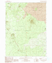 1990 Porcupine Butte1990 Print · USGSSiskiyou County's volcanic high country is captured here during the 1990s, showcasing a landscape defined by dramatic lava flows and craters. Local researchers can trace geological landmarks like the Deep Ice Caves, Porcupine Butte, and the Burnt Lava Flow Geological Area.
 - 1993 Map of Porcupine Butte, 1996 Print
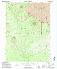 1993 Porcupine Butte1996 Print · USGSNorthern California volcanic landscapes are meticulously charted in the early nineties, showing the rugged intersection of the Shasta and Modoc national forests. Researchers can locate unique subterranean sites like the Deep Ice Caves and the Jot Dean Ice Cave near Porcupine Butte.
 - 1998 Map of Porcupine Butte, 2003 Print
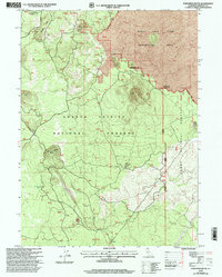 1998 Porcupine Butte2003 Print · USGSSiskiyou County's volcanic highlands are documented here during the late twentieth century, showing a landscape of craters and lava flows. Trace forestry and geologic history through Burnt Lava Flow Geological Area, the settlement of Lakin, and Porcupine Butte.
End of results
Showing maps 1-3 of 3
Frequently asked questions
- What are the different types of historical maps available for Lakin?
- What is the oldest map of Lakin?
- Where can I purchase historical maps of Lakin for my home or office?
- Where can I download high-res historical maps of Lakin?
- Are there historical topographic maps available for Lakin?
- Is there historical aerial imagery available for Lakin?
- Where are historical maps of Lakin sourced from?