1990s Maps of Pondosa, California
Explore 2 historic maps of Pondosa from the 1990s. These maps offer a rare glimpse into what life looked like during the 1990s — showing old roads, neighborhoods, homes, and landmarks that have changed or disappeared over time.
Whether you're researching your family's past, planning a metal detecting trip, or studying how Pondosa's landscape evolved across the 1990s, these high-resolution maps are a powerful tool for exploring the history of this region.
- Focus on a specific era: All maps on this page are from the 1990s, giving you a focused view of this time period.
- See what’s changed: Compare century-old streets, trails, and buildings to today's modern landscape using overlays and satellite layers.
- Research with precision: Use these maps for genealogy, historical research, land use analysis, or educational projects.
- View, download, or print: Maps are fully viewable online in high resolution, and can be downloaded or printed for your own records.
Start exploring Pondosa's history through authentic maps from the 1990s. This is your window into the past.
Pondosa, CA maps
(2)- 1990 Map of Pondosa
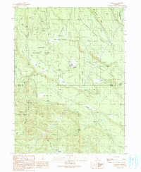 1990 Pondosa1990 Print · USGSThe timberlands of Siskiyou and Shasta counties are captured in the 1990s as a landscape of managed forests and old logging routes. Researchers can trace the Old Railroad Grade or locate family-named sites like Harlow Place and Bosworth Meadow.
 - 1998 Map of Pondosa, 2003 Print
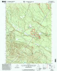 1998 Pondosa2003 Print · USGSUpper northern California timberlands and high-elevation flats are documented here at the end of the twentieth century. Researchers can locate remote sites like Harlow Place and trace water resources from Bosworth Meadow to the Pondosa Dam.
End of results
Showing maps 1-2 of 2
Frequently asked questions
- What are the different types of historical maps available for Pondosa?
- What is the oldest map of Pondosa?
- Where can I purchase historical maps of Pondosa for my home or office?
- Where can I download high-res historical maps of Pondosa?
- Are there historical topographic maps available for Pondosa?
- Is there historical aerial imagery available for Pondosa?
- Where are historical maps of Pondosa sourced from?