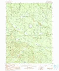
1990 Map of Pondosa
USGS Topo · Published 1990About this map
The community of Pondosa sits near the heart of this terrain, where the northern timberlands meet the high flats of the Shasta National Forest. The map documents a landscape defined by forestry and high-elevation water management, featuring the Pondosa Fire Control Sta and the Pondosa Dam along Pole Creek. The presence of an Old Railroad Grade winding through the center of the sheet suggests a history of logging transport that once moved timber toward larger rail networks. Moving south, the terrain opens into several named flats and meadows, including Dickson Flat and Bosworth Meadow, while the Siskiyou Co Shasta Co line cuts through the eastern portion of the survey. Isolated landmarks like Harlow Place and Florin Crossing provide specific points of interest for local historians tracking early settlement and stream-crossing sites in the region.
Find a feature on this map
27 named features on this map. Tap any name to fly to it.
Don’t see what you’re looking for? This feature index may not catch every label — zoom into the map to look around manually.
Map Details
Editions of this 1990 Pondosa Map
This is the sole edition of this map. No revisions or reprints were ever made.
Other maps of this area

1886 · Modoc Lava Bed
USGS Topo · 1:250,000

1892 · Modoc Lava-Bed
USGS Topo · 1:250,000

1932 · Bartle
USGS Topo · 1:96,000

1939 · Bartle
USGS Topo · 1:125,000

1954 · Alturas
USGS Topo · 1:250,000

1958 · Alturas
USGS Topo · 1:250,000

1961 · Hambone
USGS Topo · 1:62,500

1961 · Pondosa
USGS Topo · 1:62,500
1961 · Big Bend
USGS Topo · 1:62,500

1961 · Bartle
USGS Topo · 1:62,500