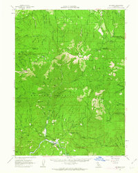
1961 Map of Big Bend
USGS Topo · Published 1963About this map
Pit River flows through the southern reach of this landscape, anchoring a pocket of settlement that includes Big Bend Rancheria and the community of Big Bend. The presence of Indian Spr Sch and a local Grave near the riverbanks suggests a small, established community dependent on the canyon's resources. Topography here is dominated by the Shasta National Forest, where high ridges like Yellow Ridge and peaks such as Grizzly Peak overlook a network of watercourses including Kosk Creek and Nelson Creek.
Find a feature on this map
106 named features on this map. Tap any name to fly to it.
Don’t see what you’re looking for? This feature index may not catch every label — zoom into the map to look around manually.
Map Details
Editions of this 1961 Big Bend Map
2 editions found
Other maps of this area

1886 · Lassen Peak
USGS Topo · 1:250,000

1886 · Modoc Lava Bed
USGS Topo · 1:250,000

1886 · Shasta
USGS Topo · 1:250,000

1890 · Red Bluff
USGS Topo · 1:250,000

1892 · Modoc Lava-Bed
USGS Topo · 1:250,000

1892 · Lassen Peak
USGS Topo · 1:250,000

1894 · Lassen Peak
USGS Topo · 1:250,000

1894 · Red Bluff
USGS Topo · 1:250,000

1894 · Shasta
USGS Topo · 1:250,000

1901 · Redding
USGS Topo · 1:125,000