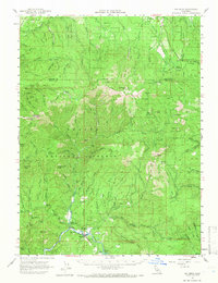
1961 Map of Big Bend
USGS Topo · Published 1966About this map
The McCloud River carves through the heart of the Shasta National Forest in this 1961 survey, where the river's path is shadowed by the decommissioned Mc Cloud River Railroad Grade. The settlement of Big Bend and the Big Bend Rancheria are the primary hubs of activity, supported by a nearby airstrip and the Indian Spr Sch. The landscape is characterized by its geothermal features, including Hunt Hot Spring and additional Hot Sprs along the riverbanks. Local history is preserved in small clearings and camps such as Arvison Flat, Grasshopper Flat, and the curiously named Walking Bear Camp. Further into the interior, the Rough and Ready Trail and a Rough and Ready (Jeep) Trail provide access to the high ground of Bald Mtn and Brushy Butte, while a lone Coal Mine suggests the area's small-scale resource extraction history.
Find a feature on this map
108 named features on this map. Tap any name to fly to it.
Don’t see what you’re looking for? This feature index may not catch every label — zoom into the map to look around manually.
Map Details
Editions of this 1961 Big Bend Map
2 editions found
Other maps of this area

1886 · Lassen Peak
USGS Topo · 1:250,000

1886 · Modoc Lava Bed
USGS Topo · 1:250,000

1886 · Shasta
USGS Topo · 1:250,000

1890 · Red Bluff
USGS Topo · 1:250,000

1892 · Modoc Lava-Bed
USGS Topo · 1:250,000

1892 · Lassen Peak
USGS Topo · 1:250,000

1894 · Lassen Peak
USGS Topo · 1:250,000

1894 · Red Bluff
USGS Topo · 1:250,000

1894 · Shasta
USGS Topo · 1:250,000

1901 · Redding
USGS Topo · 1:125,000