1900s (20th Century) Maps of Bodega Bay, California
Explore 9 historic maps of Bodega Bay from the 1900s (20th Century). These maps offer a rare glimpse into what life looked like during the 1900s — showing old roads, neighborhoods, homes, and landmarks that have changed or disappeared over time.
Whether you're researching your family's past, planning a metal detecting trip, or studying how Bodega Bay's landscape evolved across the 1900s, these high-resolution maps are a powerful tool for exploring the history of this region.
- Focus on a specific era: All maps on this page are from the 1900s, giving you a focused view of this time period.
- See what’s changed: Compare century-old streets, trails, and buildings to today's modern landscape using overlays and satellite layers.
- Research with precision: Use these maps for genealogy, historical research, land use analysis, or educational projects.
- View, download, or print: Maps are fully viewable online in high resolution, and can be downloaded or printed for your own records.
Start exploring Bodega Bay's history through authentic maps from the 1900s. This is your window into the past.
Bodega Bay, CA maps
(9)- 1942 Map of Bodega Head, 1956 Print
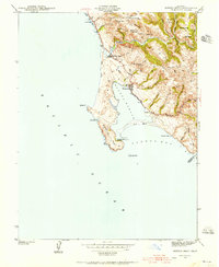 1942 Bodega Head1956 Print · USGSThe Sonoma coast during the early 1940s reveals a landscape of sheltered harbors and high coastal ridges. Genealogists and historians can trace the foundations of Bodega Bay, locate the Ocean View Sch, and explore landmarks from Arched Rock Beach to Swallow City.3 unique versions available
 - 1944 Map of Bodega Head
 1944 Bodega Head1944 Print · USGSThe Sonoma coast at the height of the Second World War shows a landscape of quiet harbors and remote coastal gulches. Researchers can trace the layout of Bodega Bay, locate the Ocean View Sch, and explore the terrain around Mount Roscoe and Swallow City.3 unique versions available
 - 1947 Map of Santa Rosa
 1947 Santa Rosa1947 Print · USGSNorthern California in the late 1940s was a landscape of agricultural valleys and vital rail hubs. Trace the historic routes of the Northwestern Pacific through Healdsburg or explore the mid-century waterfronts of Vallejo and Benicia near Mare Island.
 - 1949 Map of Santa Rosa
 1949 Santa Rosa1949 Print · USGSThe North Bay and Wine Country appear here in the late 1940s, when the Northwestern Pacific RR still dominated regional transit. Genealogists and historians can trace old coastal outposts like Anchor Bay Settlement and the early layout of Santa Rosa.2 unique versions available
 - 1958 Map of Santa Rosa, 1968 Print
 1958 Santa Rosa1968 Print · USGSThe North Bay and Wine Country are captured in the mid-twentieth century as the region balanced its agricultural roots with a growing military and recreational footprint. Researchers can trace the Northwestern Pacific RR through the Russian River valley or locate landmarks like the Petaluma Adobe Historical Monument and The Geysers Resort.3 unique versions available
 - 1962 Map of Santa Rosa
 1962 Santa Rosa1962 Print · USGSThe North Bay and Wine Country were entering a period of significant growth in the early sixties, anchored by established rail corridors and coastal maritime commerce. Genealogists and historians can trace the development of Santa Rosa, locate the Mare Island Naval Shipyard, and follow the Northwestern Pacific RR through the Cotati Valley.
 - 1964 Map of Santa Rosa
 1964 Santa Rosa1964 Print · USGSThe North Bay and Wine Country appear in the mid-fifties during a period of significant military and educational growth. Trace old rail lines like the Northwestern Pacific RR and explore historic sites from Petaluma to the Benicia Arsenal.
 - 1972 Map of Bodega Head, 1974 Print
 1972 Bodega Head1974 Print · USGSThe Sonoma coastline and the geological seam of the San Andreas Rift Zone are captured here in the early seventies. Local historians and researchers can trace the coastal developments at Bodega Bay, the scientific footprint of the University of California Marine Laboratory, and landmarks like Bodega Rock.2 unique versions available
 - 1982 Map of Bodega Bay, 1983 Print
 1982 Bodega Bay1983 Print · USGSThe Sonoma coastline and lower Russian River valley are captured here in the early eighties. Researchers can trace riverside hamlets like Monte Rio and Duncans Mills or locate coastal landmarks such as the Lighthouse and Doran County Park.
End of results
Showing maps 1-9 of 9
Top cities near Bodega Bay
- Santa Rosa historical maps
- Windsor historical maps
- Villa Grande historical maps
- Sebastopol historical maps
- Graton historical maps
- Duncans Mills historical maps
Frequently asked questions
- What are the different types of historical maps available for Bodega Bay?
- What is the oldest map of Bodega Bay?
- Where can I purchase historical maps of Bodega Bay for my home or office?
- Where can I download high-res historical maps of Bodega Bay?
- Are there historical topographic maps available for Bodega Bay?
- Is there historical aerial imagery available for Bodega Bay?
- Where are historical maps of Bodega Bay sourced from?