1900s (20th Century) Maps of Guernewood, California
Explore 10 historic maps of Guernewood from the 1900s (20th Century). These maps offer a rare glimpse into what life looked like during the 1900s — showing old roads, neighborhoods, homes, and landmarks that have changed or disappeared over time.
Whether you're researching your family's past, planning a metal detecting trip, or studying how Guernewood's landscape evolved across the 1900s, these high-resolution maps are a powerful tool for exploring the history of this region.
- Focus on a specific era: All maps on this page are from the 1900s, giving you a focused view of this time period.
- See what’s changed: Compare century-old streets, trails, and buildings to today's modern landscape using overlays and satellite layers.
- Research with precision: Use these maps for genealogy, historical research, land use analysis, or educational projects.
- View, download, or print: Maps are fully viewable online in high resolution, and can be downloaded or printed for your own records.
Start exploring Guernewood's history through authentic maps from the 1900s. This is your window into the past.
Guernewood, CA maps
(10)- 1943 Map of Duncans Mills, 1956 Print
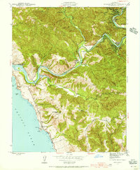 1943 Duncans Mills1956 Print · USGSThe Russian River canyon meets the Pacific in the 1940s, showing a landscape of riverside camps and coastal ranches. Trace the locations of Ocean View Sch, the settlement at Jenner, and the historic Duncans Mills river bend.2 unique versions available
 - 1945 Map of Duncans Mills
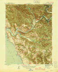 1945 Duncans Mills1945 Print · USGSThe Russian River meets the Pacific at the height of the mid-century era, revealing a landscape of riverside retreats and coastal ranching. Genealogists and historians can locate family-named landmarks like Big Buckhorn Ranch and schools such as Ocean View Sch.2 unique versions available
 - 1947 Map of Santa Rosa
 1947 Santa Rosa1947 Print · USGSNorthern California in the late 1940s was a landscape of agricultural valleys and vital rail hubs. Trace the historic routes of the Northwestern Pacific through Healdsburg or explore the mid-century waterfronts of Vallejo and Benicia near Mare Island.
 - 1949 Map of Santa Rosa
 1949 Santa Rosa1949 Print · USGSThe North Bay and Wine Country appear here in the late 1940s, when the Northwestern Pacific RR still dominated regional transit. Genealogists and historians can trace old coastal outposts like Anchor Bay Settlement and the early layout of Santa Rosa.2 unique versions available
 - 1952 Map of Duncans Mills, 1980 Print
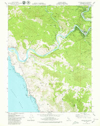
 1952 Duncans Mills1980 Print · USGSThe Russian River valley in the early 1970s is shown here as a landscape of riverside resorts and rugged Pacific coastline. Genealogists and hikers can trace old routes like Old Duncans Grade Road or locate family sites near Monte Rio and Duncans Mills.
 - 1958 Map of Santa Rosa, 1968 Print
 1958 Santa Rosa1968 Print · USGSThe North Bay and Wine Country are captured in the mid-twentieth century as the region balanced its agricultural roots with a growing military and recreational footprint. Researchers can trace the Northwestern Pacific RR through the Russian River valley or locate landmarks like the Petaluma Adobe Historical Monument and The Geysers Resort.3 unique versions available
 - 1962 Map of Santa Rosa
 1962 Santa Rosa1962 Print · USGSThe North Bay and Wine Country were entering a period of significant growth in the early sixties, anchored by established rail corridors and coastal maritime commerce. Genealogists and historians can trace the development of Santa Rosa, locate the Mare Island Naval Shipyard, and follow the Northwestern Pacific RR through the Cotati Valley.
 - 1964 Map of Santa Rosa
 1964 Santa Rosa1964 Print · USGSThe North Bay and Wine Country appear in the mid-fifties during a period of significant military and educational growth. Trace old rail lines like the Northwestern Pacific RR and explore historic sites from Petaluma to the Benicia Arsenal.
 - 1979 Map of Duncans Mills
 1979 Duncans Mills1979 Print · USGSThe Sonoma coast and the lower reaches of the Russian River are captured here in the late 1970s. Researchers can trace the river's path through old settlements like Duncans Mills and Monte Rio or locate coastal landmarks from Penny Island to Duncans Point.2 unique versions available
 - 1982 Map of Bodega Bay, 1983 Print
 1982 Bodega Bay1983 Print · USGSThe Sonoma coastline and lower Russian River valley are captured here in the early eighties. Researchers can trace riverside hamlets like Monte Rio and Duncans Mills or locate coastal landmarks such as the Lighthouse and Doran County Park.
End of results
Showing maps 1-10 of 10
Top cities near Guernewood
- Santa Rosa historical maps
- Windsor historical maps
- Villa Grande historical maps
- Healdsburg historical maps
- Sebastopol historical maps
- Graton historical maps
See more
Frequently asked questions
- What are the different types of historical maps available for Guernewood?
- What is the oldest map of Guernewood?
- Where can I purchase historical maps of Guernewood for my home or office?
- Where can I download high-res historical maps of Guernewood?
- Are there historical topographic maps available for Guernewood?
- Is there historical aerial imagery available for Guernewood?
- Where are historical maps of Guernewood sourced from?