1950s Maps of Mirabel Park, California
Explore 3 historic maps of Mirabel Park from the 1950s. These maps offer a rare glimpse into what life looked like during the 1950s — showing old roads, neighborhoods, homes, and landmarks that have changed or disappeared over time.
Whether you're researching your family's past, planning a metal detecting trip, or studying how Mirabel Park's landscape evolved across the 1950s, these high-resolution maps are a powerful tool for exploring the history of this region.
- Focus on a specific era: All maps on this page are from the 1950s, giving you a focused view of this time period.
- See what’s changed: Compare century-old streets, trails, and buildings to today's modern landscape using overlays and satellite layers.
- Research with precision: Use these maps for genealogy, historical research, land use analysis, or educational projects.
- View, download, or print: Maps are fully viewable online in high resolution, and can be downloaded or printed for your own records.
Start exploring Mirabel Park's history through authentic maps from the 1950s. This is your window into the past.
Mirabel Park, CA maps
(3)- 1954 Map of Camp Meeker, 1955 Print
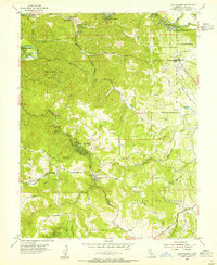 1954 Camp Meeker1955 Print · USGSWestern Sonoma County's timbered ridges and river resorts are shown here in the mid-fifties, just as the region's mid-century identity was taking shape. Researchers can trace historic property lines and community landmarks from Bohemian Grove to the Meeker Sch and Baumert Sprs.5 unique versions available
 - 1954 Map of Sebastopol, 1959 Print
 1954 Sebastopol1959 Print · USGSSonoma County's mid-century orchard lands and redwood groves are captured here just as the post-war era reshaped the region's rural character. Researchers can trace family homesteads near dozens of country schools like Vine Hill School or locate operations at the Naval Auxiliary Air Station and Two Rock Ranch Sta Military Res.
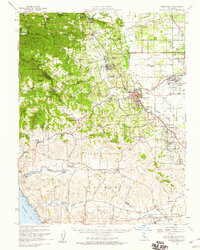
 - 1958 Map of Santa Rosa, 1968 Print
 1958 Santa Rosa1968 Print · USGSThe North Bay and Wine Country are captured in the mid-twentieth century as the region balanced its agricultural roots with a growing military and recreational footprint. Researchers can trace the Northwestern Pacific RR through the Russian River valley or locate landmarks like the Petaluma Adobe Historical Monument and The Geysers Resort.3 unique versions available
End of results
Showing maps 1-3 of 3
Top cities near Mirabel Park
- Santa Rosa historical maps
- Petaluma historical maps
- Rohnert Park historical maps
- Windsor historical maps
- Villa Grande historical maps
- Healdsburg historical maps
See more
Frequently asked questions
- What are the different types of historical maps available for Mirabel Park?
- What is the oldest map of Mirabel Park?
- Where can I purchase historical maps of Mirabel Park for my home or office?
- Where can I download high-res historical maps of Mirabel Park?
- Are there historical topographic maps available for Mirabel Park?
- Is there historical aerial imagery available for Mirabel Park?
- Where are historical maps of Mirabel Park sourced from?