Old Maps of Peterson Place, California for Academic Research
Study the evolution of Peterson Place with 10 high-resolution historic maps. Whether you're teaching, researching, or modeling changes in land use, these maps provide essential visual documentation of urban, environmental, and geographic change.
- Analyze long-term change: Track patterns in development, transportation, and natural features.
- Ideal for environmental or urban studies: Support academic projects with primary historical map data.
- Use in the classroom or lab: Educators and researchers rely on these maps to bring historical context to life.
These maps are a powerful tool for teaching, research, and visualizing how Peterson Place has changed over the decades.
Peterson Place, CA maps
(10)- 1952 Map of Anthony Peak, 1954 Print
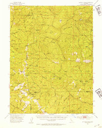 1952 Anthony Peak1954 Print · USGSHigh mountain passes and forest service outposts define this corner of the California Coast Range during the early fifties. Local historians can locate specific mountain camps and former homesteads like Griffin Place, Howell Camp, and the Maxim Cabin (Site).4 unique versions available
 - 1957 Map of Ukiah, 1966 Print
 1957 Ukiah1966 Print · USGSNorthern California's diverse terrain comes into focus in the mid-1950s, from the rugged timberlands of the Jackson State Forest to the productive Sacramento Valley. Genealogists and historians can trace the rail lines of the Northwestern Pacific or locate early valley settlements like Arbuckle and Paskenta.3 unique versions available
 - 1960 Map of Ukiah
 1960 Ukiah1960 Print · USGSNorthern California during the late fifties reveals a landscape of deep timber forests and valley agriculture before modern expansion. Trace the historic rail lines of the California Western RR and the Northwestern Pacific RR through settlements like Fort Bragg and Ukiah.2 unique versions available
 - 1967 Map of Ball Mountain, 1970 Print
 1967 Ball Mountain1970 Print · USGSTehama County's high forest ridges and seasonal grazing grounds are documented here in the late sixties. Genealogists and local historians can trace legacy sites like Johnson Cabin, Griffin Place, and the remote Lookout Tower atop Ball Mountain.4 unique versions available
 - 1987 Map of Willows, 1988 Print
 1987 Willows1988 Print · USGSThe northern Sacramento Valley meets the Coast Range in the late eighties, showing a landscape defined by water and transit. Researchers can trace the Southern Pacific railroad past Artois and Corning, or locate family-named landmarks like Larkins Childrens Rancho and Snaden Island.2 unique versions available
 - 1996 Map of Ball Mountain, 2001 Print
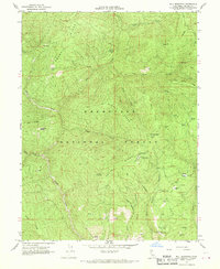
 1996 Ball Mountain2001 Print · USGSTehama County high country is shown here in the 1990s as a landscape of timber ridges and remote forestry camps. Researchers can locate seasonal outposts and glades such as Stockton Cabin, Telephone Camp, and Sugarfoot Glade.
 - 2012 Map of Ball Mountain, 2012 Print
 2012 Ball Mountain2012 Print · USGSCovers Peterson Place, including Tehama County, United States, and other nearby areas
 - 2015 Map of Ball Mountain, 2015 Print
 2015 Ball Mountain2015 Print · USGSCovers Peterson Place, including Tehama County, United States, and other nearby areas
 - 2018 Map of Ball Mountain, 2018 Print
 2018 Ball Mountain2018 Print · USGSCovers Peterson Place, including Tehama County, United States, and other nearby areas
 - 2021 Map of Ball Mountain, 2021 Print
 2021 Ball Mountain2021 Print · USGSTehama County’s high country is captured here in the contemporary era within the Mendocino National Forest. Researchers can trace the network of mountain meadows including Foreman Glade, Sugarfoot Glade, and Hensley Glade across the ridges.
End of results
Showing maps 1-10 of 10
Top cities near Peterson Place
Frequently asked questions
- What are the different types of historical maps available for Peterson Place?
- What is the oldest map of Peterson Place?
- Where can I purchase historical maps of Peterson Place for my home or office?
- Where can I download high-res historical maps of Peterson Place?
- Are there historical topographic maps available for Peterson Place?
- Is there historical aerial imagery available for Peterson Place?
- Where are historical maps of Peterson Place sourced from?