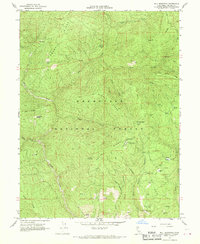
1967 Map of Ball Mountain
USGS Topo · Published 1970About this map
Mendocino National Forest defines this high-elevation landscape, where numerous family-named glades and cabins suggest a long history of seasonal grazing and forest management. This 1967 field-checked survey reveals a network of primitive tracks and trails connecting remote outposts such as Johnson Cabin, Stockton Cabin, and Russell Cabin. The drainage system is anchored by Thomes Creek, which snakes through deep canyons between prominent features like Ball Mountain and the South Ridge. Evidence of early forest service infrastructure and livestock handling is seen at the Lookout Tower on Ball Mountain and the Pollard Corral near Murphy Canyon. Scattered campsites like Big Stump Camp and Straight Arrow Camp point to the area's role for late-century recreation and wilderness access in Tehama County.
Find a feature on this map
89 named features on this map. Tap any name to fly to it.
Don’t see what you’re looking for? This feature index may not catch every label — zoom into the map to look around manually.
Map Details
Editions of this 1967 Ball Mountain Map
4 editions found
Other maps of this area

1890 · Red Bluff
USGS Topo · 1:250,000

1894 · Red Bluff
USGS Topo · 1:250,000

1949 · Colyear Springs
USGS Topo · 1:62,500

1952 · Paskenta
USGS Topo · 1:62,500

1952 · Anthony Peak
USGS Topo · 1:62,500

1954 · Yolla Bolly
USGS Topo · 1:62,500

1957 · Colyear Springs
USGS Topo · 1:62,500

1957 · Ukiah
USGS Topo · 1:250,000

1958 · Redding
USGS Topo · 1:250,000

1960 · Ukiah
USGS Topo · 1:250,000