1980s Maps of Cedar Stock, California
Explore 2 historic maps of Cedar Stock from the 1980s. These maps offer a rare glimpse into what life looked like during the 1980s — showing old roads, neighborhoods, homes, and landmarks that have changed or disappeared over time.
Whether you're researching your family's past, planning a metal detecting trip, or studying how Cedar Stock's landscape evolved across the 1980s, these high-resolution maps are a powerful tool for exploring the history of this region.
- Focus on a specific era: All maps on this page are from the 1980s, giving you a focused view of this time period.
- See what’s changed: Compare century-old streets, trails, and buildings to today's modern landscape using overlays and satellite layers.
- Research with precision: Use these maps for genealogy, historical research, land use analysis, or educational projects.
- View, download, or print: Maps are fully viewable online in high resolution, and can be downloaded or printed for your own records.
Start exploring Cedar Stock's history through authentic maps from the 1980s. This is your window into the past.
Cedar Stock, CA maps
(2)- 1982 Map of Trinity Dam
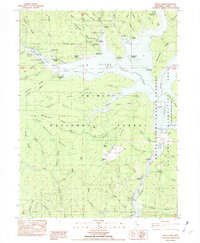 1982 Trinity Dam1982 Print · USGSThe Trinity River canyon is shown just after its mid-century transformation into a major reservoir in this 1980s provisional study. Researchers can locate submerged history at Ridgeville (Site) and trace mining legacy at the Hydraulic Mine or Little Anna Mine.
 - 1984 Map of Redding
 1984 Redding1984 Print · USGSThe Shasta County region in the mid-1980s reveals a landscape of massive reservoirs and active mining districts. Researchers can trace the development of Redding and Enterprise or locate historic mineral sites like Iron Mountain Mine and Keystone Mine.2 unique versions available
End of results
Showing maps 1-2 of 2
Top cities near Cedar Stock
Frequently asked questions
- What are the different types of historical maps available for Cedar Stock?
- What is the oldest map of Cedar Stock?
- Where can I purchase historical maps of Cedar Stock for my home or office?
- Where can I download high-res historical maps of Cedar Stock?
- Are there historical topographic maps available for Cedar Stock?
- Is there historical aerial imagery available for Cedar Stock?
- Where are historical maps of Cedar Stock sourced from?