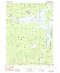
1982 Map of Trinity Dam
USGS Topo · Published 1982About this map
Trinity Dam and the sprawling waters of Clair Engle Lake dominate this 1982 provisional study of the California mountains. The landscape is defined by the transformation of the Trinity River canyon, where the massive dam and its associated Powerplant replaced earlier canyon floor settlements. Traces of the region's mining heritage remain visible through several named sites, including a Hydraulic Mine near Stuart Fork Picnic Area and smaller operations like the Buckeye Mine and Little Elsie Mine tucked into the steep drainages of the Trinity National Forest.
Find a feature on this map
85 named features on this map. Tap any name to fly to it.
Don’t see what you’re looking for? This feature index may not catch every label — zoom into the map to look around manually.
Map Details
Editions of this 1982 Trinity Dam Map
This is the sole edition of this map. No revisions or reprints were ever made.
Other maps of this area

1890 · Red Bluff
USGS Topo · 1:250,000

1894 · Red Bluff
USGS Topo · 1:250,000

1913 · Weaverville
USGS Topo · 1:125,000

1944 · French Gulch
USGS Topo · 1:62,500

1948 · French Gulch
USGS Topo · 1:62,500

1950 · Minersville
USGS Topo · 1:62,500

1950 · Schell Mtn
USGS Topo · 1:62,500

1950 · Weaverville
USGS Topo · 1:62,500
1952 · Schell Mtn.
USGS Topo · 1:62,500

1952 · Weaverville
USGS Topo · 1:62,500