
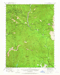
1944 Map of French Gulch
USGS Topo · Published 1957About this map
Gold and copper mining history dominates this 1944 survey of the Trinity and Shasta county line. The landscape is heavily marked by the legacy of the 19th-century rush, with dozens of active and defunct operations such as the Brown Bear Mine, Gladstone Mine, and Milkmaid Mine scattered across the steep ridges. The settlement of French Gulch serves as a central hub along Clear Creek, while further south, the community of Whiskeytown appears before the valley was transformed by later water projects.
Find a feature on this map
90 named features on this map. Tap any name to fly to it.
Don’t see what you’re looking for? This feature index may not catch every label — zoom into the map to look around manually.
Map Details
Editions of this 1944 French Gulch Map
2 editions found
Other maps of this area

1890 · Red Bluff
USGS Topo · 1:250,000

1894 · Red Bluff
USGS Topo · 1:250,000

1901 · Redding
USGS Topo · 1:125,000

1913 · Weaverville
USGS Topo · 1:125,000

1932 · Olinda
USGS Topo · 1:31,680

1935 · Olinda
USGS Topo · 1:31,680

1944 · Redding
USGS Topo · 1:62,500

1946 · Lamoine
USGS Topo · 1:62,500

1946 · Redding
USGS Topo · 1:62,500

1947 · Anderson
USGS Topo · 1:62,500