1900s (20th Century) Maps of Trinity Village, California
Explore 7 historic maps of Trinity Village from the 1900s (20th Century). These maps offer a rare glimpse into what life looked like during the 1900s — showing old roads, neighborhoods, homes, and landmarks that have changed or disappeared over time.
Whether you're researching your family's past, planning a metal detecting trip, or studying how Trinity Village's landscape evolved across the 1900s, these high-resolution maps are a powerful tool for exploring the history of this region.
- Focus on a specific era: All maps on this page are from the 1900s, giving you a focused view of this time period.
- See what’s changed: Compare century-old streets, trails, and buildings to today's modern landscape using overlays and satellite layers.
- Research with precision: Use these maps for genealogy, historical research, land use analysis, or educational projects.
- View, download, or print: Maps are fully viewable online in high resolution, and can be downloaded or printed for your own records.
Start exploring Trinity Village's history through authentic maps from the 1900s. This is your window into the past.
Trinity Village, CA maps
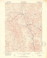
(7)- 1915 Map of Big Bar and Vicinity
 1915 Big Bar and Vicinity1915 Print · USGSThe Trinity River wilderness in the early twentieth century was a landscape of isolated mining outposts and river settlements. Genealogists and historians can trace the early footprints of Junction City, Helena, and Hyampom alongside remote landmarks like Keystone Cabin.5 unique versions available
 - 1922 Map of China Flat
 1922 China Flat1922 Print · USGSNorthwestern California at the dawn of the 1920s reveals a landscape of isolated river settlements and early forest service outposts. Genealogists and historians can trace the residents of Quinby and Uptons or locate the China Flat Post Office and Handy Horse Ranger Station.
 - 1952 Map of Willow Creek, 1954 Print
 1952 Willow Creek1954 Print · USGSThe Trinity River valley in the early fifties shows a mountain landscape of remote ranches and forest stations. Genealogists and historians can locate family landmarks like Russell Cabin, the Horse Mtn Mine, and the Cedar Grove Ranch.4 unique versions available
 - 1958 Map of Redding
 1958 Redding1958 Print · USGSNorthern California's valley and mountain landscapes are captured in the late fifties, showing the region as new reservoirs reshaped the river systems. Genealogists and historians can trace rail-side towns like Cottonwood, the military presence at Red Bluff Air Force Station, and mountain outposts like Weaverville.5 unique versions available
 - 1979 Map of Salyer
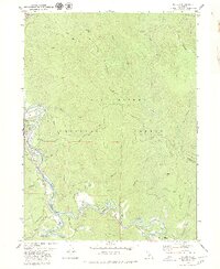 1979 Salyer1979 Print · USGSIn the late 1970s, the Klamath Mountains landscape was defined by the winding waters of the Trinity River. Genealogists and historians can trace riverside settlements like Salyer and Trinity Village, or locate the Cem and Mine sites tucked along the ridges.2 unique versions available
 - 1982 Map of Hayfork, 1983 Print
 1982 Hayfork1983 Print · USGSTrinity and Humboldt counties appear here in the early eighties as a landscape of timber and mining. Researchers can trace remote river settlements like Hyampom and Burnt Ranch or locate old operations such as the Yellowstone Mine and Index Mine.
 - 1997 Map of Salyer, 2001 Print
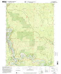 1997 Salyer2001 Print · USGSThe Trinity River canyon in the late nineties was a landscape of small mountain outposts and vast protected forests. Genealogists and historians can trace the foundations of local life at Salyer, Trinity Village, and Sandy Bar, or locate the Schoolhouse and Mine that once served the community.
End of results
Showing maps 1-7 of 7
Frequently asked questions
- What are the different types of historical maps available for Trinity Village?
- What is the oldest map of Trinity Village?
- Where can I purchase historical maps of Trinity Village for my home or office?
- Where can I download high-res historical maps of Trinity Village?
- Are there historical topographic maps available for Trinity Village?
- Is there historical aerial imagery available for Trinity Village?
- Where are historical maps of Trinity Village sourced from?