1900s (20th Century) Maps of Wigdon Place, California
Explore 7 historic maps of Wigdon Place from the 1900s (20th Century). These maps offer a rare glimpse into what life looked like during the 1900s — showing old roads, neighborhoods, homes, and landmarks that have changed or disappeared over time.
Whether you're researching your family's past, planning a metal detecting trip, or studying how Wigdon Place's landscape evolved across the 1900s, these high-resolution maps are a powerful tool for exploring the history of this region.
- Focus on a specific era: All maps on this page are from the 1900s, giving you a focused view of this time period.
- See what’s changed: Compare century-old streets, trails, and buildings to today's modern landscape using overlays and satellite layers.
- Research with precision: Use these maps for genealogy, historical research, land use analysis, or educational projects.
- View, download, or print: Maps are fully viewable online in high resolution, and can be downloaded or printed for your own records.
Start exploring Wigdon Place's history through authentic maps from the 1900s. This is your window into the past.
Wigdon Place, CA maps
(7)- 1909 Map of Big Bar
 1909 Big Bar1909 Print · USGSTrinity County at the turn of the century shows a land defined by deep river canyons and remote mountain settlements. Genealogists and local historians can trace early footprints at Hyampom and Hayfork, or locate the high ridges of Barker Mtn and Thompson Peak.2 unique versions available
 - 1915 Map of Big Bar and Vicinity
 1915 Big Bar and Vicinity1915 Print · USGSThe Trinity River wilderness in the early twentieth century was a landscape of isolated mining outposts and river settlements. Genealogists and historians can trace the early footprints of Junction City, Helena, and Hyampom alongside remote landmarks like Keystone Cabin.5 unique versions available
 - 1951 Map of Hyampom, 1953 Print
 1951 Hyampom1953 Print · USGSThe Trinity County mountains in the early fifties show a landscape of remote ranching and forest management. Researchers can locate family holdings like Grel Ranch, remote outposts at Camp Trinity, and the vital Landing Field at Hyampom.4 unique versions available
 - 1958 Map of Redding
 1958 Redding1958 Print · USGSNorthern California's valley and mountain landscapes are captured in the late fifties, showing the region as new reservoirs reshaped the river systems. Genealogists and historians can trace rail-side towns like Cottonwood, the military presence at Red Bluff Air Force Station, and mountain outposts like Weaverville.5 unique versions available
 - 1982 Map of Hyampom Mtn.
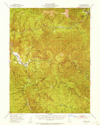
 1982 Hyampom Mtn.1982 Print · USGSThe Trinity County mountains come into focus in the early eighties as the river and forest management shape local life. Genealogists and historians can locate family-named sites like Skunk Ranch and Wigdon Place or trace recreation at Big Slide Campground.
 - 1982 Map of Hayfork, 1983 Print
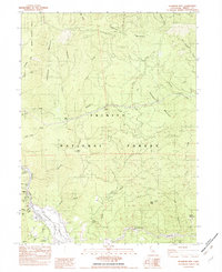
 1982 Hayfork1983 Print · USGSTrinity and Humboldt counties appear here in the early eighties as a landscape of timber and mining. Researchers can trace remote river settlements like Hyampom and Burnt Ranch or locate old operations such as the Yellowstone Mine and Index Mine.
 - 1998 Map of Hyampom Mountain, 2003 Print
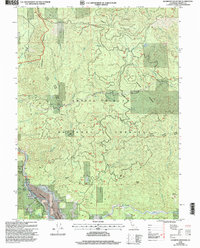 1998 Hyampom Mountain2003 Print · USGSTrinity County at the close of the twentieth century shows a landscape where forest management meets river-valley industry. Genealogists and historians can trace family-named sites like Skunk Ranch and Wigdon Place alongside the active Sawmill and Hyampom Airport.
End of results
Showing maps 1-7 of 7
Top cities near Wigdon Place
Frequently asked questions
- What are the different types of historical maps available for Wigdon Place?
- What is the oldest map of Wigdon Place?
- Where can I purchase historical maps of Wigdon Place for my home or office?
- Where can I download high-res historical maps of Wigdon Place?
- Are there historical topographic maps available for Wigdon Place?
- Is there historical aerial imagery available for Wigdon Place?
- Where are historical maps of Wigdon Place sourced from?