1940s Maps of Poso Park, California
Explore 3 historic maps of Poso Park from the 1940s. These maps offer a rare glimpse into what life looked like during the 1940s — showing old roads, neighborhoods, homes, and landmarks that have changed or disappeared over time.
Whether you're researching your family's past, planning a metal detecting trip, or studying how Poso Park's landscape evolved across the 1940s, these high-resolution maps are a powerful tool for exploring the history of this region.
- Focus on a specific era: All maps on this page are from the 1940s, giving you a focused view of this time period.
- See what’s changed: Compare century-old streets, trails, and buildings to today's modern landscape using overlays and satellite layers.
- Research with precision: Use these maps for genealogy, historical research, land use analysis, or educational projects.
- View, download, or print: Maps are fully viewable online in high resolution, and can be downloaded or printed for your own records.
Start exploring Poso Park's history through authentic maps from the 1940s. This is your window into the past.
Poso Park, CA maps
(3)- 1943 Map of Tobias Peak
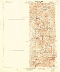 1943 Tobias Peak1943 Print · USGSThe southern Sierra Nevada foothills in the early 1940s are defined by high-elevation meadows and a legacy of mountain ranching. Researchers can locate early schools and mines, including Greenhorn Sch, the Tungsten Mine, and the historic mining camp of Keysville.2 unique versions available
 - 1945 Map of Tobias Peak
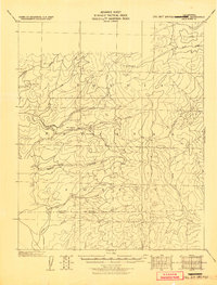 1945 Tobias Peak1945 Print · USGSTulare and Kern County mountain territories are captured here at the end of the Second World War. Researchers can trace high-country life through old outposts like Hot Springs, Pine Flat, and Cranston, or locate early meadows such as Double Bunk.
 - 1948 Map of Bakersfield
 1948 Bakersfield1948 Print · USGSBakersfield and the southern San Joaquin Valley appear in the late 1940s, showing a landscape of burgeoning oil towns, rail junctions, and early irrigation canals. Genealogists and historians can trace the foundations of local industry through Gardner Field, the Sunset Railway, and the shores of Buena Vista Lake.2 unique versions available
End of results
Showing maps 1-3 of 3
Top cities near Poso Park
Frequently asked questions
- What are the different types of historical maps available for Poso Park?
- What is the oldest map of Poso Park?
- Where can I purchase historical maps of Poso Park for my home or office?
- Where can I download high-res historical maps of Poso Park?
- Are there historical topographic maps available for Poso Park?
- Is there historical aerial imagery available for Poso Park?
- Where are historical maps of Poso Park sourced from?