1950s Maps of Three Rivers, California
Explore 5 historic maps of Three Rivers from the 1950s. These maps offer a rare glimpse into what life looked like during the 1950s — showing old roads, neighborhoods, homes, and landmarks that have changed or disappeared over time.
Whether you're researching your family's past, planning a metal detecting trip, or studying how Three Rivers's landscape evolved across the 1950s, these high-resolution maps are a powerful tool for exploring the history of this region.
- Focus on a specific era: All maps on this page are from the 1950s, giving you a focused view of this time period.
- See what’s changed: Compare century-old streets, trails, and buildings to today's modern landscape using overlays and satellite layers.
- Research with precision: Use these maps for genealogy, historical research, land use analysis, or educational projects.
- View, download, or print: Maps are fully viewable online in high resolution, and can be downloaded or printed for your own records.
Start exploring Three Rivers's history through authentic maps from the 1950s. This is your window into the past.
Three Rivers, CA maps
(5)- 1955 Map of Fresno
 1955 Fresno1955 Print · USGSThe Central Valley and High Sierra meet in this mid-fifties study of California’s agricultural and wilderness heart. Researchers can trace the rail-side growth of Sanger, Selma, and Reedley or locate high-altitude landmarks like Mt Whitney and Hume Lake.
 - 1956 Map of Fresno
 1956 Fresno1956 Print · USGSThe Central Valley and High Sierra meet in this mid-fifties survey of a rapidly developing California interior. Researchers can trace the rail-and-water networks of Visalia, the footprint of Tulare Lake, and the remote heights of Sequoia National Park.
 - 1956 Map of Giant Forest, 1958 Print
 1956 Giant Forest1958 Print · USGSThe High Sierra groves were transitioning into a major recreational destination in the late 1950s. Genealogists and historians can trace the early park infrastructure at Colony Mill Ranger Station, find the small community of Wilsonia, and locate the iconic General Sherman Tree.4 unique versions available
 - 1957 Map of Kaweah, 1958 Print
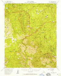
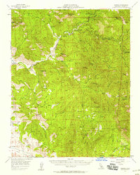 1957 Kaweah1958 Print · USGSIn the Sierra Nevada foothills during the late 1950s, Three Rivers sits at the gateway to the high country. Researchers can trace the early layout of Ash Mountain Natl Park Hdqrs, locate Blue Ridge School, and find remote outposts like Milk Ranch.5 unique versions available
 - 1958 Map of Fresno
 1958 Fresno1958 Print · USGSThe Central Valley and High Sierra meet in this mid-century survey of the California heartland. Researchers can trace the rail-and-road network connecting Fresno and Visalia or locate high-country landmarks like Mt Whitney and Sequoia National Park.
End of results
Showing maps 1-5 of 5
Top cities near Three Rivers
Top neighborhoods of Three Rivers
Frequently asked questions
- What are the different types of historical maps available for Three Rivers?
- What is the oldest map of Three Rivers?
- Where can I purchase historical maps of Three Rivers for my home or office?
- Where can I download high-res historical maps of Three Rivers?
- Are there historical topographic maps available for Three Rivers?
- Is there historical aerial imagery available for Three Rivers?
- Where are historical maps of Three Rivers sourced from?