1920s Maps of Tooleville, California
Explore 2 historic maps of Tooleville from the 1920s. These maps offer a rare glimpse into what life looked like during the 1920s — showing old roads, neighborhoods, homes, and landmarks that have changed or disappeared over time.
Whether you're researching your family's past, planning a metal detecting trip, or studying how Tooleville's landscape evolved across the 1920s, these high-resolution maps are a powerful tool for exploring the history of this region.
- Focus on a specific era: All maps on this page are from the 1920s, giving you a focused view of this time period.
- See what’s changed: Compare century-old streets, trails, and buildings to today's modern landscape using overlays and satellite layers.
- Research with precision: Use these maps for genealogy, historical research, land use analysis, or educational projects.
- View, download, or print: Maps are fully viewable online in high resolution, and can be downloaded or printed for your own records.
Start exploring Tooleville's history through authentic maps from the 1920s. This is your window into the past.
Tooleville, CA maps
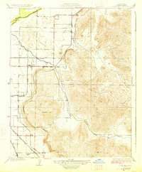
(2)- 1925 Map of Rocky Hill
 1925 Rocky Hill1925 Print · USGSTulare County in the mid-1920s reveals a sophisticated network of irrigation and electric rail servicing the eastern San Joaquin Valley. Researchers can trace early school sites like Lindcove School and the infrastructure of the Visalia Electric and Sides Siding.
 - 1927 Map of Rocky Hill
 1927 Rocky Hill1927 Print · USGSIn the late 1920s, this Tulare County landscape shows the intricate marriage of irrigation and rail that built the valley's citrus belt. Genealogists and historians can trace the exact locations of the Lind Cove School, the Merryman station, and the path of the Visalia Electric railroad.3 unique versions available
End of results
Showing maps 1-2 of 2
Top cities near Tooleville
- Visalia historical maps
- Porterville historical maps
- Tulare historical maps
- Exeter historical maps
- Lindsay historical maps
- Farmersville historical maps
See more
Frequently asked questions
- What are the different types of historical maps available for Tooleville?
- What is the oldest map of Tooleville?
- Where can I purchase historical maps of Tooleville for my home or office?
- Where can I download high-res historical maps of Tooleville?
- Are there historical topographic maps available for Tooleville?
- Is there historical aerial imagery available for Tooleville?
- Where are historical maps of Tooleville sourced from?