
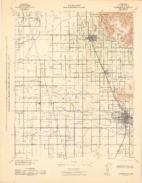
1925 Map of Rocky Hill
USGS Topo · Published 1925About this map
The Kaweah River and its intricate irrigation network define this 1925 landscape of Tulare County. The terrain is dominated by the prominent elevations of Rocky Hill and the adjacent Yokohl Valley, where the agricultural economy of the mid-1920s is evidenced by the Lindsay Strathmore Irrigation Ditch. This era shows a transition in regional transportation, with the Visalia Electric line running parallel to the older heavy rail corridors of the Atchison Topeka and Santa Fe and the Southern Pacific.
Find a feature on this map
18 named features on this map. Tap any name to fly to it.
Don’t see what you’re looking for? This feature index may not catch every label — zoom into the map to look around manually.
Map Details
Editions of this 1925 Rocky Hill Map
This is the sole edition of this map. No revisions or reprints were ever made.
Other maps of this area

1904 · Kaweah
USGS Topo · 1:125,000

1909 · Kaweah
USGS Topo · 1:125,000

1926 · Ivanhoe
USGS Topo · 1:31,680

1926 · Exeter
USGS Topo · 1:31,680

1927 · Cairns Corner
USGS Topo · 1:31,680

1927 · Rocky Hill
USGS Topo · 1:31,680

1928 · Lemon Cove
USGS Topo · 1:31,680

1928 · Lindsay
USGS Topo · 1:31,680

1937 · Kaweah
USGS Topo · 1:125,000
1942 · Porterville
USGS Topo · 1:62,500