1928 Map of Lemon Cove
USGS Topo · Published 1928About this map
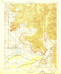
The Kaweah River and St Johns River converge in this agricultural landscape as it appeared in the mid-1920s. Centered on the growing citrus and ranching hub of Woodlake, the map illustrates a complex hydraulic and transport system essential to the San Joaquin Valley. Irrigation is managed through features like the Wutchumna Ditch and Long Canal, while the Atchison Topeka and Santa Fe railroad provides the backbone for moving local harvests.
Find a feature on this map
41 named features on this map. Tap any name to fly to it.
Don’t see what you’re looking for? This feature index may not catch every label — zoom into the map to look around manually.
Map Details
Editions of this 1928 Lemon Cove Map
This is the sole edition of this map. No revisions or reprints were ever made.
Other maps of this area

1903 · Tehipite
USGS Topo · 1:125,000

1904 · Kaweah
USGS Topo · 1:125,000

1905 · Tehipite
USGS Topo · 1:125,000

1909 · Kaweah
USGS Topo · 1:125,000

1921 · Stokes Mountain
USGS Topo · 1:24,000

1922 · Trimmer
USGS Topo · 1:96,000

1924 · Dinuba
USGS Topo · 1:125,000

1924 · Stokes Mountain
USGS Topo · 1:31,680

1925 · Rocky Hill
USGS Topo · 1:31,680

1926 · Ivanhoe
USGS Topo · 1:31,680