
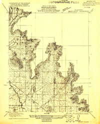
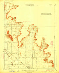
1921 Map of Stokes Mountain
USGS Topo · Published 1957About this map
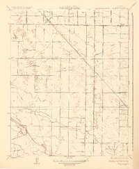
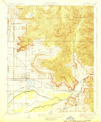
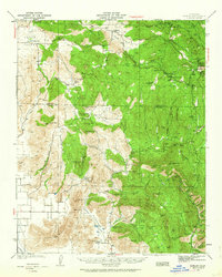
Stokes Mountain dominates this 1921 survey of the Tulare County foothills, where the abrupt transition from the San Joaquin Valley floor to the Sierra Nevada range is clearly visible. The map details a landscape of expanding agricultural utility and early infrastructure, centered on the Woodlake Valley corridor. Modern researchers can find the local center of community education at the Elda School, while the presence of the A. T. & S. F. railroad line at the southern edge of the survey illustrates the vital transportation link for this region's rural economy. The intricate topographic work by T.H.Moncure and C.A.Stonesifer captures the drainage patterns of Sand Creek and Cottonwood Creek as they emerge from the upland canyons, providing a technical look at the water resources that shaped early California land use and settlement in this portion of the county.
Find a feature on this map
8 named features on this map. Tap any name to fly to it.
Don’t see what you’re looking for? This feature index may not catch every label — zoom into the map to look around manually.
Map Details
Editions of this 1921 Stokes Mountain Map
This is the sole edition of this map. No revisions or reprints were ever made.
Other maps of this area
1921 · Squaw Valley
USGS Topo · 1:31,680

1922 · Trimmer
USGS Topo · 1:96,000

1923 · Sultana
USGS Topo · 1:31,680
1924 · Citrus Cove
USGS Topo · 1:31,680

1924 · Dinuba
USGS Topo · 1:125,000

1924 · Stokes Mountain
USGS Topo · 1:31,680

1926 · Ivanhoe
USGS Topo · 1:31,680
1927 · Monson
USGS Topo · 1:31,680
1928 · Lemon Cove
USGS Topo · 1:31,680
1942 · Dunlap
USGS Topo · 1:62,500