
1904 Map of Kaweah
USGS Topo · Published 1904About this map
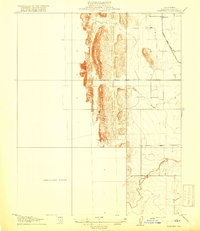
Sequoia National Park dominates the high country of this 1904 survey, preserving a landscape where early industry and recreation intersected. The map highlights the rugged timber and milling history of the region through markers like Atwells Mill on the East Fork Kaweah River and Dillon Mill to the south. Along the lower elevations, the settlement of Three Rivers sits at the confluence of the forks, while the presence of Daunt P.O. and Springville indicates the established ranching and agricultural communities of the valley floor. Water management is a central theme, evidenced by an intricate network of irrigation channels including the Whitney Ditch, Pioneer Ditch, and Plano Ditch, which redirected the flow of the Kaweah River and its tributaries to support the growing Yokohl Valley and Frazier Valley. This early twentieth-century snapshot documents the transition from raw wilderness and industrial extraction to the managed landscapes of the National Park and Tule River Indian Reservation.
Find a feature on this map
130 named features on this map. Tap any name to fly to it.
Don’t see what you’re looking for? This feature index may not catch every label — zoom into the map to look around manually.
Map Details
Editions of this 1904 Kaweah Map
This is the sole edition of this map. No revisions or reprints were ever made.
Other maps of this area

1903 · Tehipite
USGS Topo · 1:125,000

1905 · Tehipite
USGS Topo · 1:125,000

1905 · Olancha
USGS Topo · 1:125,000

1905 · Fairview
USGS Topo · 1:24,000

1906 · Kernville
USGS Topo · 1:125,000

1907 · Olancha
USGS Topo · 1:125,000

1907 · Mt. Whitney
USGS Topo · 1:125,000

1908 · Kernville
USGS Topo · 1:125,000

1909 · Kaweah
USGS Topo · 1:125,000
1918 · Fairview
USGS Topo · 1:31,680