
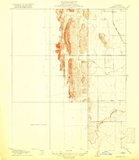
1905 Map of Fairview
USGS Topo · Published 1957About this map
Fairview sits at the edge of the Coast Range foothills in Colusa County, recorded during a detailed 1904-1905 survey by the State of California Department of Engineering. The landscape is defined by the sharp transition from the steep, ridged uplands to the west into the flatter agricultural basins to the east. Transportation during this era was dominated by the Colusa and Lake railroad, which skirts the eastern edge of the foothills near the northern part of the map. Drainage patterns are vital to this terrain, characterized by the winding path of Freshwater Creek in the south and the Glenn Valley Slough further north, reflecting the natural water management of the valley floor before mid-century modifications.
Find a feature on this map
6 named features on this map. Tap any name to fly to it.
Don’t see what you’re looking for? This feature index may not catch every label — zoom into the map to look around manually.
Map Details
Editions of this 1905 Fairview Map
This is the sole edition of this map. No revisions or reprints were ever made.
Other maps of this area

1904 · Kaweah
USGS Topo · 1:125,000

1905 · Olancha
USGS Topo · 1:125,000

1906 · Kernville
USGS Topo · 1:125,000

1907 · Olancha
USGS Topo · 1:125,000

1908 · Kernville
USGS Topo · 1:125,000

1909 · Kaweah
USGS Topo · 1:125,000
1918 · Fairview
USGS Topo · 1:31,680

1936 · Tobias Peak
USGS Topo · 1:125,000

1937 · Kaweah
USGS Topo · 1:125,000
1943 · Tobias Peak
USGS Topo · 1:125,000