
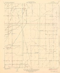
1927 Map of Cairns Corner
USGS Topo · Published 1927About this map
Cairns Corner and the surrounding agricultural landscape of Tulare County are captured here in the mid-1920s, revealing a meticulously managed water system essential for San Joaquin Valley farming. The map details an intricate network of natural and man-made waterways, including Inside Creek, Outside Creek, and the Gray Ditch, which redirect water across the valley floor. This infrastructure supported a growing community anchored by rural institutions such as the Church of the Brethren and several local education hubs like Central School and Prairie Center School.
Find a feature on this map
21 named features on this map. Tap any name to fly to it.
Don’t see what you’re looking for? This feature index may not catch every label — zoom into the map to look around manually.
Map Details
Editions of this 1927 Cairns Corner Map
2 editions found
Other maps of this area

1925 · Rocky Hill
USGS Topo · 1:31,680

1925 · Tulare
USGS Topo · 1:31,680

1925 · Tipton
USGS Topo · 1:31,680

1926 · Exeter
USGS Topo · 1:31,680

1927 · Rocky Hill
USGS Topo · 1:31,680

1927 · Visalia
USGS Topo · 1:31,680

1927 · Tulare
USGS Topo · 1:31,680

1928 · Tipton
USGS Topo · 1:31,680

1928 · Woodville
USGS Topo · 1:31,680

1928 · Lindsay
USGS Topo · 1:31,680