
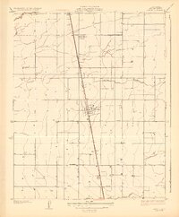
1928 Map of Tipton
USGS Topo · Published 1928About this map
Tipton serves as the central hub of this 1920s agricultural landscape, situated along the dominant line of the Southern Pacific railroad. The map illustrates a highly organized grid of rural infrastructure, where naming conventions like Vineyard Road, Macomber Road, and Oakland Road reflect the early development of the Tulare County countryside. This era shows a transition between natural watercourses and irrigation-driven settlement, with the Tule River and Mitchell Slough meandering through a landscape increasingly defined by straight section lines and small community clusters.
Find a feature on this map
17 named features on this map. Tap any name to fly to it.
Don’t see what you’re looking for? This feature index may not catch every label — zoom into the map to look around manually.
Map Details
Editions of this 1928 Tipton Map
2 editions found
Other maps of this area

1925 · Tulare
USGS Topo · 1:31,680

1925 · Tipton
USGS Topo · 1:31,680

1927 · Cairns Corner
USGS Topo · 1:31,680

1927 · Lake View School
USGS Topo · 1:31,680

1927 · Paige
USGS Topo · 1:31,680

1927 · Tulare
USGS Topo · 1:31,680

1928 · Woodville
USGS Topo · 1:31,680

1929 · Alpaugh
USGS Topo · 1:31,680

1929 · Sausalito School
USGS Topo · 1:31,680

1929 · Pixley
USGS Topo · 1:31,680