1940s Maps of Browns Valley, California
Explore 3 historic maps of Browns Valley from the 1940s. These maps offer a rare glimpse into what life looked like during the 1940s — showing old roads, neighborhoods, homes, and landmarks that have changed or disappeared over time.
Whether you're researching your family's past, planning a metal detecting trip, or studying how Browns Valley's landscape evolved across the 1940s, these high-resolution maps are a powerful tool for exploring the history of this region.
- Focus on a specific era: All maps on this page are from the 1940s, giving you a focused view of this time period.
- See what’s changed: Compare century-old streets, trails, and buildings to today's modern landscape using overlays and satellite layers.
- Research with precision: Use these maps for genealogy, historical research, land use analysis, or educational projects.
- View, download, or print: Maps are fully viewable online in high resolution, and can be downloaded or printed for your own records.
Start exploring Browns Valley's history through authentic maps from the 1940s. This is your window into the past.
Browns Valley, CA maps
(3)- 1947 Map of Browns Valley, 1957 Print
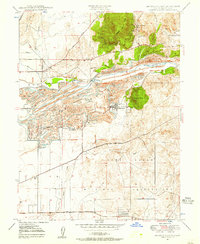 1947 Browns Valley1957 Print · USGSYuba County in the late 1940s reveals a landscape shaped by gold dredging and military expansion. You can trace the dredge fields surrounding Hammonton and Marigold or locate historic schools and mines like the Pennsylvania Mine and Brophy Sch.5 unique versions available
 - 1949 Map of Browns Valley
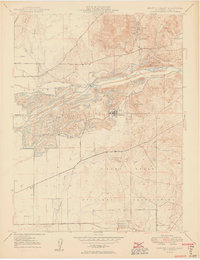 1949 Browns Valley1949 Print · USGSYuba County during the late 1940s reveals a landscape defined by hydraulic engineering and the massive footprint of wartime mobilization. You can trace the development of Hammonton and Marigold alongside the Camp Beale Military Reservation and historic mines like the Pennsylvania Mine.2 unique versions available
 - 1949 Map of Wheatland, 1953 Print
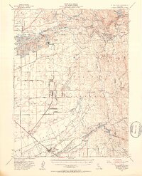 1949 Wheatland1953 Print · USGSYuba and Nevada counties appear here during the postwar transition of the late 1940s, showing a landscape defined by massive gold dredging and military expansion. Genealogists and historians can trace the foundations of Camp Beale Military Reservation or locate early mining sites like Timbuctoo and the Pennsylvania Mine.3 unique versions available
End of results
Showing maps 1-3 of 3
Top cities near Browns Valley
- Yuba City historical maps
- Linda historical maps
- Olivehurst historical maps
- Oroville historical maps
- Marysville historical maps
- Plumas Lake historical maps
See more
Frequently asked questions
- What are the different types of historical maps available for Browns Valley?
- What is the oldest map of Browns Valley?
- Where can I purchase historical maps of Browns Valley for my home or office?
- Where can I download high-res historical maps of Browns Valley?
- Are there historical topographic maps available for Browns Valley?
- Is there historical aerial imagery available for Browns Valley?
- Where are historical maps of Browns Valley sourced from?