Old Maps of Browns Valley, California for Genealogy
Trace your family roots with 13 historic maps of Browns Valley. These high-res maps reveal old neighborhoods, homesites, landmarks, and streets — helping you uncover where your ancestors lived and how the area evolved over time.
- Explore historic neighborhoods: Identify where your relatives may have lived in the 1800s or 1900s.
- Compare maps over time: Trace the changes in streets, buildings, and landmarks for multi-generational research.
- Perfect for genealogy & ancestry research: Used by family historians and researchers to map out lineage and migration.
These maps are an incredible resource for exploring your personal connection to Browns Valley's past.
Browns Valley, CA maps
(13)- 1888 Map of Smartsville
 1888 Smartsville1888 Print · USGSCovers Browns Valley, including Grass Valley, Wheatland, and other nearby areas
 - 1891 Map of Smartsville
 1891 Smartsville1891 Print · USGSCovers Browns Valley, including Grass Valley, Wheatland, and other nearby areas
 - 1892 Map of Smartsville
 1892 Smartsville1892 Print · USGSCovers Browns Valley, including Grass Valley, Wheatland, and other nearby areas
 - 1894 Map of Smartsville
 1894 Smartsville1894 Print · USGSCovers Browns Valley, including Grass Valley, Wheatland, and other nearby areas
 - 1895 Map of Smartsville
 1895 Smartsville1895 Print · USGSCovers Browns Valley, including Grass Valley, Wheatland, and other nearby areas6 unique versions available
 - 1911 Map of Browns Valley
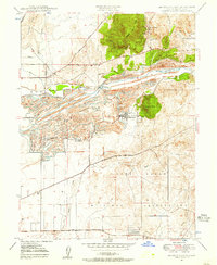
 1911 Browns Valley1911 Print · USGSCovers Browns Valley, including Hammonton, Yuba County, and other nearby areas
 - 1947 Map of Browns Valley, 1957 Print
 1947 Browns Valley1957 Print · USGSCovers Browns Valley, including Hammonton, Yuba County, and other nearby areas5 unique versions available
 - 1949 Map of Browns Valley
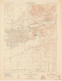 1949 Browns Valley1949 Print · USGSCovers Browns Valley, including Hammonton, Yuba County, and other nearby areas2 unique versions available
 - 1949 Map of Wheatland, 1953 Print
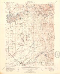 1949 Wheatland1953 Print · USGSCovers Browns Valley, including Wheatland, Sicard Flat, and other nearby areas3 unique versions available
 - 1958 Map of Chico, 1962 Print
 1958 Chico1962 Print · USGSCovers Browns Valley, including Reno, Chico, and other nearby areas4 unique versions available
 - 1960 Map of Chico
 1960 Chico1960 Print · USGSCovers Browns Valley, including Reno, Chico, and other nearby areas
 - 1993 Map of Yuba City, 1994 Print
 1993 Yuba City1994 Print · USGSCovers Browns Valley, including Yuba City, Linda, and other nearby areas
 - 2021 Map of Browns Valley, 2021 Print
 2021 Browns Valley2021 Print · USGSCovers Browns Valley, including Hammonton, Yuba County, and other nearby areas
End of results
Showing maps 1-13 of 13
Top cities near Browns Valley
- Yuba City historical maps
- Linda historical maps
- Olivehurst historical maps
- Oroville historical maps
- Marysville historical maps
- Plumas Lake historical maps
See more
Frequently asked questions
- What are the different types of historical maps available for Browns Valley?
- What is the oldest map of Browns Valley?
- Where can I purchase historical maps of Browns Valley for my home or office?
- Where can I download high-res historical maps of Browns Valley?
- Are there historical topographic maps available for Browns Valley?
- Is there historical aerial imagery available for Browns Valley?
- Where are historical maps of Browns Valley sourced from?