1960s Maps of Alamosa, Colorado
Explore 4 historic maps of Alamosa from the 1960s. These maps offer a rare glimpse into what life looked like during the 1960s — showing old roads, neighborhoods, homes, and landmarks that have changed or disappeared over time.
Whether you're researching your family's past, planning a metal detecting trip, or studying how Alamosa's landscape evolved across the 1960s, these high-resolution maps are a powerful tool for exploring the history of this region.
- Focus on a specific era: All maps on this page are from the 1960s, giving you a focused view of this time period.
- See what’s changed: Compare century-old streets, trails, and buildings to today's modern landscape using overlays and satellite layers.
- Research with precision: Use these maps for genealogy, historical research, land use analysis, or educational projects.
- View, download, or print: Maps are fully viewable online in high resolution, and can be downloaded or printed for your own records.
Start exploring Alamosa's history through authentic maps from the 1960s. This is your window into the past.
Alamosa, CO maps
(4)- 1966 Map of Mount Pleasant School, 1968 Print
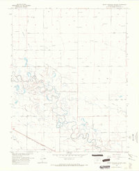 1966 Mount Pleasant School1968 Print · USGSAlamosa County’s San Luis Valley was a hub of intensive irrigation and rail transport in the mid-1960s. Researchers can trace the path of the Denver and Rio Grande Western railroad and locate rural landmarks like Mount Pleasant School and the Costilla Canal.
 - 1966 Map of Hooper SE, 1968 Print
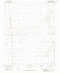 1966 Hooper SE1968 Print · USGSAlamosa County appears in the mid-1960s as a landscape of grid-patterned roads and intensive water management. Researchers can trace the path of the Old Railroad Grade or locate historic water sources like the Costilla Canal and numerous Flowing Wells.
 - 1966 Map of Alamosa East, 1968 Print
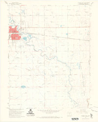 1966 Alamosa East1968 Print · USGSAlamosa and the surrounding San Luis Valley are captured here in the mid-sixties, showcasing a landscape defined by the Rio Grande and a complex network of irrigation ditches. Researchers can trace the path of the Denver and Rio Grande Western railroad and locate local landmarks like the Boyd Sch and Adams Lake.3 unique versions available
 - 1966 Map of Alamosa West, 1969 Print
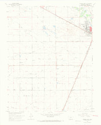 1966 Alamosa West1969 Print · USGSThe high plains of Alamosa County come into sharp focus in the mid-1960s, showing a landscape defined by industrial rail and irrigation. Trace the Denver and Rio Grande Western tracks through La Fruto and Henry, or locate family landmarks like Waverly Sch.3 unique versions available
End of results
Showing maps 1-4 of 4
Top cities near Alamosa
Frequently asked questions
- What are the different types of historical maps available for Alamosa?
- What is the oldest map of Alamosa?
- Where can I purchase historical maps of Alamosa for my home or office?
- Where can I download high-res historical maps of Alamosa?
- Are there historical topographic maps available for Alamosa?
- Is there historical aerial imagery available for Alamosa?
- Where are historical maps of Alamosa sourced from?