1930s Maps of Aurora, Colorado
Explore 4 historic maps of Aurora from the 1930s. These maps offer a rare glimpse into what life looked like during the 1930s — showing old roads, neighborhoods, homes, and landmarks that have changed or disappeared over time.
Whether you're researching your family's past, planning a metal detecting trip, or studying how Aurora's landscape evolved across the 1930s, these high-resolution maps are a powerful tool for exploring the history of this region.
- Focus on a specific era: All maps on this page are from the 1930s, giving you a focused view of this time period.
- See what’s changed: Compare century-old streets, trails, and buildings to today's modern landscape using overlays and satellite layers.
- Research with precision: Use these maps for genealogy, historical research, land use analysis, or educational projects.
- View, download, or print: Maps are fully viewable online in high resolution, and can be downloaded or printed for your own records.
Start exploring Aurora's history through authentic maps from the 1930s. This is your window into the past.
Aurora, CO maps
(4)- 1935 Map of East Denver Nos. 3 and 4
 1935 East Denver Nos. 3 and 41935 Print · USGSSoutheast Denver and the surrounding High Plains are captured here in the mid-1930s as residential growth began to push into Douglas County. Researchers can locate early landmarks like Fairmount Cemetery, the settlement of Sullivan, and the Melvin Sch.
 - 1938 Map of Derby, 1955 Print
 1938 Derby1955 Print · USGSThe industrial and aviation landscape north of Denver is captured here during the late Depression era, showing a transition from dense urban rail hubs to irrigated farmland. Researchers can trace the legacy of the Stockyards, the Riverside Cemetery, and early runways at the Municipal Airport.
 - 1938 Map of Long Branch, 1957 Print
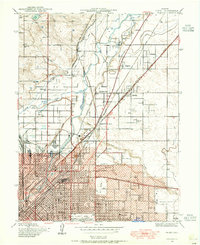
 1938 Long Branch1957 Print · USGSThe outskirts of Denver in the late 1930s reveal a landscape of military installations, rail lines, and irrigation works. Trace the early boundaries of Aurora and locate local landmarks like Rose Hill Sch and Fitzsimons General Hospital.
 - 1939 Map of Coal Creek, 1955 Print
 1939 Coal Creek1955 Print · USGSThe rural boundary of Arapahoe and Adams counties is captured here in the late 1930s, showing the high plains before urban expansion. Genealogists and local historians can trace the paths of Airline Road and the Union Pacific railroad, or find the site of the old Coal Creek Sch.
End of results
Showing maps 1-4 of 4
Top cities near Aurora
- Thornton historical maps
- Centennial historical maps
- Parker historical maps
- Commerce City historical maps
- Brighton historical maps
- Greenwood Village historical maps
See more
Top neighborhoods of Aurora
- Windler Sub #01 historical maps
- Sable historical maps
- Altura historical maps
- East Quincy Highlands historical maps
- Horizon Uptown historical maps
- Peninsula historical maps
See more
Frequently asked questions
- What are the different types of historical maps available for Aurora?
- What is the oldest map of Aurora?
- Where can I purchase historical maps of Aurora for my home or office?
- Where can I download high-res historical maps of Aurora?
- Are there historical topographic maps available for Aurora?
- Is there historical aerial imagery available for Aurora?
- Where are historical maps of Aurora sourced from?