1890s Maps of Marlman, Colorado
Explore 2 historic maps of Marlman from the 1890s. These maps offer a rare glimpse into what life looked like during the 1890s — showing old roads, neighborhoods, homes, and landmarks that have changed or disappeared over time.
Whether you're researching your family's past, planning a metal detecting trip, or studying how Marlman's landscape evolved across the 1890s, these high-resolution maps are a powerful tool for exploring the history of this region.
- Focus on a specific era: All maps on this page are from the 1890s, giving you a focused view of this time period.
- See what’s changed: Compare century-old streets, trails, and buildings to today's modern landscape using overlays and satellite layers.
- Research with precision: Use these maps for genealogy, historical research, land use analysis, or educational projects.
- View, download, or print: Maps are fully viewable online in high resolution, and can be downloaded or printed for your own records.
Start exploring Marlman's history through authentic maps from the 1890s. This is your window into the past.
Marlman, CO maps
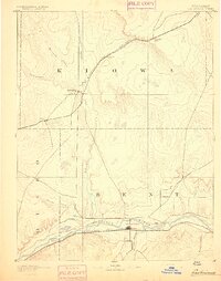
(2)- 1891 Map of Las Animas
 1891 Las Animas1891 Print · USGSSoutheast Colorado in the early 1890s centers on the confluence of the Arkansas River and Purgatoire River at Las Animas. Researchers can trace the early rail networks of the Atchison Topeka and Santa Fe Railroad and find historic sites like Fort Lyon.
 - 1893 Map of Las Animas
 1893 Las Animas1893 Print · USGSSoutheastern Colorado was a bustling corridor of rail and river commerce in the 1890s as the frontier closed. Genealogists and historians can trace the development of Las Animas and Fort Lyon alongside the tracks of the Atchison Topeka and Santa Fe Railroad.5 unique versions available
End of results
Showing maps 1-2 of 2
Top cities near Marlman
Frequently asked questions
- What are the different types of historical maps available for Marlman?
- What is the oldest map of Marlman?
- Where can I purchase historical maps of Marlman for my home or office?
- Where can I download high-res historical maps of Marlman?
- Are there historical topographic maps available for Marlman?
- Is there historical aerial imagery available for Marlman?
- Where are historical maps of Marlman sourced from?