1940s Maps of Bonanza Mountain Estates, Colorado
Explore 2 historic maps of Bonanza Mountain Estates from the 1940s. These maps offer a rare glimpse into what life looked like during the 1940s — showing old roads, neighborhoods, homes, and landmarks that have changed or disappeared over time.
Whether you're researching your family's past, planning a metal detecting trip, or studying how Bonanza Mountain Estates's landscape evolved across the 1940s, these high-resolution maps are a powerful tool for exploring the history of this region.
- Focus on a specific era: All maps on this page are from the 1940s, giving you a focused view of this time period.
- See what’s changed: Compare century-old streets, trails, and buildings to today's modern landscape using overlays and satellite layers.
- Research with precision: Use these maps for genealogy, historical research, land use analysis, or educational projects.
- View, download, or print: Maps are fully viewable online in high resolution, and can be downloaded or printed for your own records.
Start exploring Bonanza Mountain Estates's history through authentic maps from the 1940s. This is your window into the past.
Bonanza Mountain Estates, CO maps
(2)- 1942 Map of Tungsten, 1955 Print
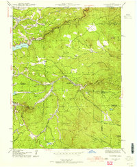 1942 Tungsten1955 Print · USGSBoulder and Gilpin counties come alive in the 1940s as mining and mountain ranching define the high-country landscape. Genealogists and historians can trace the Denver and Salt Lake rail line through Pinecliffe P O and find remote sites like the Kekionga Mine.5 unique versions available
 - 1944 Map of Tungsten
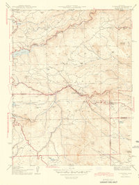 1944 Tungsten1944 Print · USGSBoulder and Gilpin counties are captured here in the mid-1940s, as mountain railroads and mining operations shaped the Front Range. Genealogists can trace family footprints at Lincoln Hills, Pine Glade Sch, and the Kekionga Mine.
End of results
Showing maps 1-2 of 2
Top cities near Bonanza Mountain Estates
- Arvada historical maps
- Boulder historical maps
- Idaho Springs historical maps
- Nederland historical maps
- Empire historical maps
- Jamestown historical maps
See more
Frequently asked questions
- What are the different types of historical maps available for Bonanza Mountain Estates?
- What is the oldest map of Bonanza Mountain Estates?
- Where can I purchase historical maps of Bonanza Mountain Estates for my home or office?
- Where can I download high-res historical maps of Bonanza Mountain Estates?
- Are there historical topographic maps available for Bonanza Mountain Estates?
- Is there historical aerial imagery available for Bonanza Mountain Estates?
- Where are historical maps of Bonanza Mountain Estates sourced from?