1940s Maps of Cherry Creek Highlands, Parker
Explore 2 historic maps of Cherry Creek Highlands from the 1940s. These maps offer a rare glimpse into what life looked like during the 1940s — showing old roads, neighborhoods, homes, and landmarks that have changed or disappeared over time.
Whether you're researching your family's past, planning a metal detecting trip, or studying how Cherry Creek Highlands's landscape evolved across the 1940s, these high-resolution maps are a powerful tool for exploring the history of this region.
- Focus on a specific era: All maps on this page are from the 1940s, giving you a focused view of this time period.
- See what’s changed: Compare century-old streets, trails, and buildings to today's modern landscape using overlays and satellite layers.
- Research with precision: Use these maps for genealogy, historical research, land use analysis, or educational projects.
- View, download, or print: Maps are fully viewable online in high resolution, and can be downloaded or printed for your own records.
Start exploring Cherry Creek Highlands's history through authentic maps from the 1940s. This is your window into the past.
Cherry Creek Highlands, Parker maps
(2)- 1942 Map of Parker
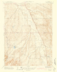 1942 Parker1942 Print · USGSSoutheast of Denver in the late thirties and early forties, this landscape shows the rural agricultural roots and water management systems of Douglas County. Genealogists can locate family-named landmarks and community centers like Parker, Melvin, and the Happy Canyon Sch.
 - 1949 Map of Parker
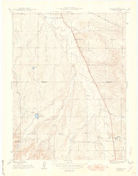 1949 Parker1949 Print · USGSThe high plains south of Denver are captured here in the late 1940s, a period of rural agriculture before the region's rapid suburban growth. Genealogists and historians can trace old homestead routes and irrigation works like the Arapaho Canal or find the sites of Cherry Creek Sch and Melvin.
End of results
Showing maps 1-2 of 2
Top cities near Cherry Creek Highlands
- Aurora historical maps
- Highlands Ranch historical maps
- Centennial historical maps
- Castle Rock historical maps
- Parker historical maps
- Littleton historical maps
See more
Frequently asked questions
- What are the different types of historical maps available for Cherry Creek Highlands?
- What is the oldest map of Cherry Creek Highlands?
- Where can I purchase historical maps of Cherry Creek Highlands for my home or office?
- Where can I download high-res historical maps of Cherry Creek Highlands?
- Are there historical topographic maps available for Cherry Creek Highlands?
- Is there historical aerial imagery available for Cherry Creek Highlands?
- Where are historical maps of Cherry Creek Highlands sourced from?