1970s Maps of Vail, Colorado
Explore 4 historic maps of Vail from the 1970s. These maps offer a rare glimpse into what life looked like during the 1970s — showing old roads, neighborhoods, homes, and landmarks that have changed or disappeared over time.
Whether you're researching your family's past, planning a metal detecting trip, or studying how Vail's landscape evolved across the 1970s, these high-resolution maps are a powerful tool for exploring the history of this region.
- Focus on a specific era: All maps on this page are from the 1970s, giving you a focused view of this time period.
- See what’s changed: Compare century-old streets, trails, and buildings to today's modern landscape using overlays and satellite layers.
- Research with precision: Use these maps for genealogy, historical research, land use analysis, or educational projects.
- View, download, or print: Maps are fully viewable online in high resolution, and can be downloaded or printed for your own records.
Start exploring Vail's history through authentic maps from the 1970s. This is your window into the past.
Vail, CO maps
(4)- 1970 Map of Vail East, 1973 Print
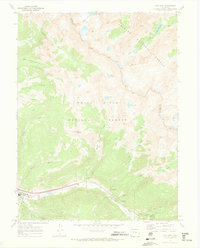 1970 Vail East1973 Print · USGSThe Eagle County high country was rapidly evolving in the early seventies as recreation took root near the Eagle-Summit county line. Trace the early development of Vail and the Ski Area alongside mountain landmarks like Bald Mountain.5 unique versions available
 - 1970 Map of Vail West, 1973 Print
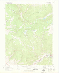 1970 Vail West1973 Print · USGSThe Eagle County high country is shown here just as Vail was establishing its modern footprint. You can trace early backcountry access via the Nottingham Ridge Trail and locate recreation sites like Piney Lake and Piney Campground.3 unique versions available
 - 1970 Map of Red Cliff, 1973 Print
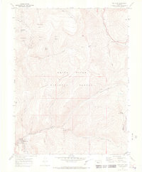 1970 Red Cliff1973 Print · USGSRed Cliff at the start of the 1970s shows a high-mountain community where mining heritage meets the burgeoning ski industry. Genealogists and historians can locate the local Cemetery, the D & RG W RR line, and historic mining sites like the Hornsilver Mine.5 unique versions available
 - 1970 Map of Minturn, 1973 Print
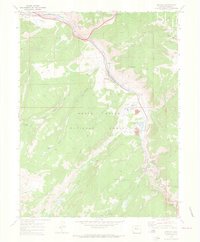 1970 Minturn1973 Print · USGSMinturn and the Eagle River valley are shown here in the early 1970s, balancing a mountain railroad economy with industrial mining. Researchers can trace the Denver and Rio Grande Western Railroad to the Eagle Mine and locate the River View Cemetery.5 unique versions available
End of results
Showing maps 1-4 of 4
Top cities near Vail
Top neighborhoods of Vail
- Bighorn historical maps
- West Vail historical maps
- Solaris Plaza historical maps
- World Plaza historical maps
- Eaton Plaza historical maps
- Mountain Plaza historical maps
See more
Frequently asked questions
- What are the different types of historical maps available for Vail?
- What is the oldest map of Vail?
- Where can I purchase historical maps of Vail for my home or office?
- Where can I download high-res historical maps of Vail?
- Are there historical topographic maps available for Vail?
- Is there historical aerial imagery available for Vail?
- Where are historical maps of Vail sourced from?