1970s Maps of Ramah, Colorado
Explore 2 historic maps of Ramah from the 1970s. These maps offer a rare glimpse into what life looked like during the 1970s — showing old roads, neighborhoods, homes, and landmarks that have changed or disappeared over time.
Whether you're researching your family's past, planning a metal detecting trip, or studying how Ramah's landscape evolved across the 1970s, these high-resolution maps are a powerful tool for exploring the history of this region.
- Focus on a specific era: All maps on this page are from the 1970s, giving you a focused view of this time period.
- See what’s changed: Compare century-old streets, trails, and buildings to today's modern landscape using overlays and satellite layers.
- Research with precision: Use these maps for genealogy, historical research, land use analysis, or educational projects.
- View, download, or print: Maps are fully viewable online in high resolution, and can be downloaded or printed for your own records.
Start exploring Ramah's history through authentic maps from the 1970s. This is your window into the past.
Ramah, CO maps
(2)- 1970 Map of Ramah South, 1973 Print
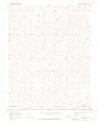
 1970 Ramah South1973 Print · USGSEl Paso County ranching and rail infrastructure are captured here in the early seventies as the railroad still served the high plains. Trace the path of the Chicago Rock Island and Pacific through Ramah or locate rural landmarks like Ramah Reservoir and Paint Mine Road.
 - 1970 Map of Ramah North, 1973 Print
 1970 Ramah North1973 Print · USGSEastern Elbert County appears here just as the early seventies began, showing the rural landscape around Ramah. Genealogists and local historians can trace family-named sites like Sproch Cem, Sakaia Cem, and the St Mary Ch.3 unique versions available
End of results
Showing maps 1-2 of 2
Top cities near Ramah
Frequently asked questions
- What are the different types of historical maps available for Ramah?
- What is the oldest map of Ramah?
- Where can I purchase historical maps of Ramah for my home or office?
- Where can I download high-res historical maps of Ramah?
- Are there historical topographic maps available for Ramah?
- Is there historical aerial imagery available for Ramah?
- Where are historical maps of Ramah sourced from?