1960s Maps of Security-Widefield, Colorado
Explore 6 historic maps of Security-Widefield from the 1960s. These maps offer a rare glimpse into what life looked like during the 1960s — showing old roads, neighborhoods, homes, and landmarks that have changed or disappeared over time.
Whether you're researching your family's past, planning a metal detecting trip, or studying how Security-Widefield's landscape evolved across the 1960s, these high-resolution maps are a powerful tool for exploring the history of this region.
- Focus on a specific era: All maps on this page are from the 1960s, giving you a focused view of this time period.
- See what’s changed: Compare century-old streets, trails, and buildings to today's modern landscape using overlays and satellite layers.
- Research with precision: Use these maps for genealogy, historical research, land use analysis, or educational projects.
- View, download, or print: Maps are fully viewable online in high resolution, and can be downloaded or printed for your own records.
Start exploring Security-Widefield's history through authentic maps from the 1960s. This is your window into the past.
Security-Widefield, CO maps
(6)- 1961 Map of Cheyenne Mountain, 1963 Print
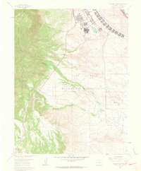 1961 Cheyenne Mountain1963 Print · USGSEl Paso County in the early sixties showcases the intersection of military expansion and Front Range wilderness. Trace the boundaries of the Fort Carson Military Reservation alongside landmarks like Hitch Rack Ranch and the Louisiana State University Camp.9 unique versions available
 - 1961 Map of Colorado Springs, 1963 Print
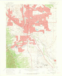 1961 Colorado Springs1963 Print · USGSColorado Springs was undergoing significant growth in the early sixties, as suburban developments expanded toward the surrounding military installations. Researchers can trace the layout of Ent Air Force Base, find family sites in Evergreen Cemetery, or locate vanished schoolhouses like Wasson High Sch.7 unique versions available
 - 1961 Map of Fountain, 1963 Print
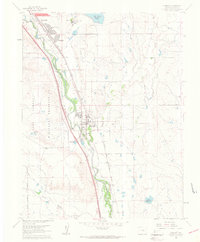 1961 Fountain1963 Print · USGSEl Paso County at the start of the sixties shows a landscape of rapid suburban growth and military presence. Genealogists and historians can trace the early developments of Security and Widefield or locate rail sites like Crews and Holmes.9 unique versions available
 - 1961 Map of Elsmere, 1963 Print
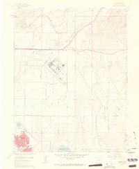 1961 Elsmere1963 Print · USGSThe high plains of El Paso County are captured here in the early sixties as military aviation and suburban growth begin to transform the landscape. Researchers can trace the development of Security, locate early schools like Sproul Sch, and explore features like Peterson Field and the Pikes Peak Speedway.9 unique versions available
 - 1962 Map of Pueblo
 1962 Pueblo1962 Print · USGSThe Front Range and high plains meet in the early sixties as military installations and industrial mining shape the corridor from Colorado Springs to Pueblo. Genealogists can trace family names through rural landmarks like the Columbine School, Hanover Church, and Fairview Cem.
 - 1966 Map of Pueblo
 1966 Pueblo1966 Print · USGSThe Front Range and Arkansas River Valley are captured here in the mid-1960s, showing a landscape shaped by mining, military expansion, and rail. Researchers can locate numerous country schools and mines, such as the Lytle School, Pioneer Cem, and Empire Zinc Mine.
End of results
Showing maps 1-6 of 6
Top cities near Security-Widefield
Top neighborhoods of Security-Widefield
Frequently asked questions
- What are the different types of historical maps available for Security-Widefield?
- What is the oldest map of Security-Widefield?
- Where can I purchase historical maps of Security-Widefield for my home or office?
- Where can I download high-res historical maps of Security-Widefield?
- Are there historical topographic maps available for Security-Widefield?
- Is there historical aerial imagery available for Security-Widefield?
- Where are historical maps of Security-Widefield sourced from?