1950s Maps of Erie, Colorado
Explore 6 historic maps of Erie from the 1950s. These maps offer a rare glimpse into what life looked like during the 1950s — showing old roads, neighborhoods, homes, and landmarks that have changed or disappeared over time.
Whether you're researching your family's past, planning a metal detecting trip, or studying how Erie's landscape evolved across the 1950s, these high-resolution maps are a powerful tool for exploring the history of this region.
- Focus on a specific era: All maps on this page are from the 1950s, giving you a focused view of this time period.
- See what’s changed: Compare century-old streets, trails, and buildings to today's modern landscape using overlays and satellite layers.
- Research with precision: Use these maps for genealogy, historical research, land use analysis, or educational projects.
- View, download, or print: Maps are fully viewable online in high resolution, and can be downloaded or printed for your own records.
Start exploring Erie's history through authentic maps from the 1950s. This is your window into the past.
Erie, CO maps
(6)- 1950 Map of Frederick
 1950 Frederick1950 Print · USGSThe coal-rich corridor of Weld County is caught in a moment of industrial transition during the early 1950s. Genealogists and historians can trace the mining family hubs of Frederick, Firestone, and Dacono, alongside local schools like Mount View School and the Shamrock Mine.7 unique versions available
 - 1950 Map of Erie, 1956 Print
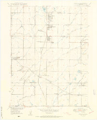
 1950 Erie1956 Print · USGSIn the mid-century landscape of the Colorado plains, coal mining and irrigation dictate the growth of towns and transport. Genealogists can trace family roots through markers like the Columbine Mine, Gooding School, and Erie Cem.
 - 1951 Map of Erie
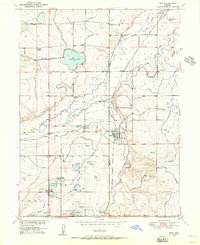
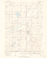 1951 Erie1951 Print · USGSThe mining and agricultural corridor of Weld and Boulder counties is captured here in the early 1950s. Researchers can trace dozens of individual operations like the Morrison Mine and Erie Mine, or locate family sites near the Gooding School and Erie Cemetery.
 - 1954 Map of Greeley, 1966 Print
 1954 Greeley1966 Print · USGSNorthern Colorado transitions from high-alpine peaks to the irrigated South Platte valley during this mid-century period of growth. Genealogists and historians can trace rail-connected hubs like Greeley and Longmont alongside landmarks like Horsetooth Reservoir and Estes Park.3 unique versions available
 - 1957 Map of Greeley
 1957 Greeley1957 Print · USGSNorthern Colorado in the mid-fifties is captured here as the agricultural plains of Weld County meet the high peaks of the Front Range. Genealogists and historians can trace rail-linked towns like Keenesburg and Roggen or locate early water features such as Boyd Lake and Fossil Creek Reservoir.
 - 1958 Map of Greeley
 1958 Greeley1958 Print · USGSNorthern Colorado and the high peaks of the Front Range appear here in the mid-fifties as the region's agricultural and rail networks were fully established. Genealogists can locate family homes near Virginia Dale, Waverly, or Kuner, and trace the path of the Union Pacific Railroad through Greeley.
End of results
Showing maps 1-6 of 6
Top cities near Erie
- Aurora historical maps
- Thornton historical maps
- Arvada historical maps
- Westminster historical maps
- Boulder historical maps
- Longmont historical maps
See more
Top neighborhoods of Erie
- Leyner historical maps
- Ninemile Corner historical maps
- Tabor historical maps
- Erie Air Park historical maps
- Baxter Farm historical maps
- Sunwest North historical maps
See more
Frequently asked questions
- What are the different types of historical maps available for Erie?
- What is the oldest map of Erie?
- Where can I purchase historical maps of Erie for my home or office?
- Where can I download high-res historical maps of Erie?
- Are there historical topographic maps available for Erie?
- Is there historical aerial imagery available for Erie?
- Where are historical maps of Erie sourced from?