1940s Maps of Columbine Campground, Colorado
Explore 2 historic maps of Columbine Campground from the 1940s. These maps offer a rare glimpse into what life looked like during the 1940s — showing old roads, neighborhoods, homes, and landmarks that have changed or disappeared over time.
Whether you're researching your family's past, planning a metal detecting trip, or studying how Columbine Campground's landscape evolved across the 1940s, these high-resolution maps are a powerful tool for exploring the history of this region.
- Focus on a specific era: All maps on this page are from the 1940s, giving you a focused view of this time period.
- See what’s changed: Compare century-old streets, trails, and buildings to today's modern landscape using overlays and satellite layers.
- Research with precision: Use these maps for genealogy, historical research, land use analysis, or educational projects.
- View, download, or print: Maps are fully viewable online in high resolution, and can be downloaded or printed for your own records.
Start exploring Columbine Campground's history through authentic maps from the 1940s. This is your window into the past.
Columbine Campground, CO maps
(2)- 1942 Map of Central City, 1955 Print
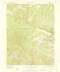 1942 Central City1955 Print · USGSGilpin County’s gold mining heartland is captured here during the early Forties, centered on the intense industrial activity around Central City. Researchers can trace the era's mining infrastructure through features like The Glory Hole, Pittsburg Mine, and the Bald Mtn Cem.5 unique versions available
 - 1944 Map of Central City
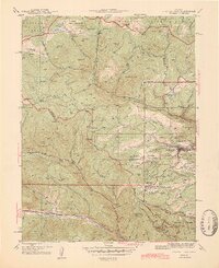 1944 Central City1944 Print · USGSMid-century Colorado mining country is documented here, centering on the historic Gilpin County district during the 1940s. Genealogists and historians can trace the foundations of Central City, locate the massive Glory Hole, and find smaller settlements like Nevadaville and Apex.2 unique versions available
End of results
Showing maps 1-2 of 2
Top cities near Columbine Campground
- Idaho Springs historical maps
- Nederland historical maps
- Georgetown historical maps
- Empire historical maps
- Silver Plume historical maps
- Black Hawk historical maps
Frequently asked questions
- What are the different types of historical maps available for Columbine Campground?
- What is the oldest map of Columbine Campground?
- Where can I purchase historical maps of Columbine Campground for my home or office?
- Where can I download high-res historical maps of Columbine Campground?
- Are there historical topographic maps available for Columbine Campground?
- Is there historical aerial imagery available for Columbine Campground?
- Where are historical maps of Columbine Campground sourced from?