1980s Maps of Kremmling, Colorado
Explore 3 historic maps of Kremmling from the 1980s. These maps offer a rare glimpse into what life looked like during the 1980s — showing old roads, neighborhoods, homes, and landmarks that have changed or disappeared over time.
Whether you're researching your family's past, planning a metal detecting trip, or studying how Kremmling's landscape evolved across the 1980s, these high-resolution maps are a powerful tool for exploring the history of this region.
- Focus on a specific era: All maps on this page are from the 1980s, giving you a focused view of this time period.
- See what’s changed: Compare century-old streets, trails, and buildings to today's modern landscape using overlays and satellite layers.
- Research with precision: Use these maps for genealogy, historical research, land use analysis, or educational projects.
- View, download, or print: Maps are fully viewable online in high resolution, and can be downloaded or printed for your own records.
Start exploring Kremmling's history through authentic maps from the 1980s. This is your window into the past.
Kremmling, CO maps
(3)- 1980 Map of Junction Butte, 1981 Print
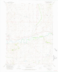 1980 Junction Butte1981 Print · USGSGrand County ranching and rail history intersect here in the early eighties as the town of Kremmling anchors the valley. Researchers can trace the Denver and Rio Grande railway or locate family-named landmarks like Taussig Reservoir No 1 and Lawson Ridge.2 unique versions available
 - 1980 Map of Steamboat Springs, 1982 Print
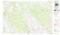 1980 Steamboat Springs1982 Print · USGSNorthwest Colorado's ranching and rail corridors come to life in the early eighties as mountain recreation and resource management began to reshape the region. Researchers can trace the Denver and Rio Grande Western line through Oak Creek or locate local landmarks like Old Homestead and Egeria Park.
 - 1981 Map of Kremmling
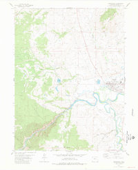 1981 Kremmling1981 Print · USGSThe river-and-rail hub of Kremmling is captured here in the early eighties at the confluence of the COLORADO RIVER and Blue River. Genealogists and local historians can trace the town's footprint, including the West Grand High Sch and the rail line through Gore Canyon.2 unique versions available
End of results
Showing maps 1-3 of 3
Frequently asked questions
- What are the different types of historical maps available for Kremmling?
- What is the oldest map of Kremmling?
- Where can I purchase historical maps of Kremmling for my home or office?
- Where can I download high-res historical maps of Kremmling?
- Are there historical topographic maps available for Kremmling?
- Is there historical aerial imagery available for Kremmling?
- Where are historical maps of Kremmling sourced from?