1900s (20th Century) Maps of Somerset, Colorado
Explore 8 historic maps of Somerset from the 1900s (20th Century). These maps offer a rare glimpse into what life looked like during the 1900s — showing old roads, neighborhoods, homes, and landmarks that have changed or disappeared over time.
Whether you're researching your family's past, planning a metal detecting trip, or studying how Somerset's landscape evolved across the 1900s, these high-resolution maps are a powerful tool for exploring the history of this region.
- Focus on a specific era: All maps on this page are from the 1900s, giving you a focused view of this time period.
- See what’s changed: Compare century-old streets, trails, and buildings to today's modern landscape using overlays and satellite layers.
- Research with precision: Use these maps for genealogy, historical research, land use analysis, or educational projects.
- View, download, or print: Maps are fully viewable online in high resolution, and can be downloaded or printed for your own records.
Start exploring Somerset's history through authentic maps from the 1900s. This is your window into the past.
Somerset, CO maps
(8)- 1938 Map of Mt. Gunnison
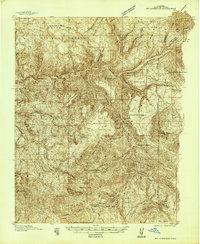 1938 Mt. Gunnison1938 Print · USGSGunnison County is shown here in the late 1930s, a period defined by high-altitude ranching and the early development of the North Fork valley. Genealogists and historians can trace the locations of old working camps and ranch sites like Davenport Ranch, Berdine, and Hammond Cow Camp.5 unique versions available
 - 1945 Map of Mount Gunnison
 1945 Mount Gunnison1945 Print · USGSGunnison and Delta counties are shown in the mid-1940s during a time when high-country cabins and stock trails defined the landscape. Researchers can trace the Munsey Ruby Stock Driveway or locate remote sites like Bardine and Snowshoe Cabin.2 unique versions available
 - 1956 Map of Montrose, 1963 Print
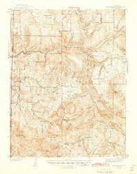
 1956 Montrose1963 Print · USGSThe Colorado western slope in the late fifties and early sixties shows a landscape defined by the Denver & Rio Grande Western RR and the Gunnison River. Trace the development of Blue Mesa Reservoir or locate high-country sites like the Bachelor Mine.3 unique versions available
 - 1959 Map of Montrose
 1959 Montrose1959 Print · USGSWestern Colorado in the late fifties is defined by the high peaks and river valleys of the Southern Rockies. Genealogists and historians can trace the paths of the Denver & Rio Grande Western RR or locate mountain settlements like Crawford, Lazear, and Doyleville.
 - 1960 Map of Montrose
 1960 Montrose1960 Print · USGSThe Colorado high country in the mid-fifties is captured here during a period of steady ranching and persistent mining. Researchers can trace the path of the Denver & Rio Grande Western RR or locate small settlements like Somerset, Maher, and Sargent.2 unique versions available
 - 1964 Map of Somerset, 1967 Print
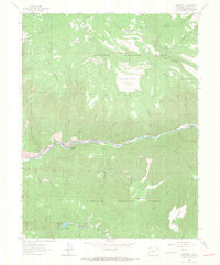 1964 Somerset1967 Print · USGSCoal mining and rail transport define this Gunnison County canyon during the mid-sixties. Researchers can trace the industrial footprint of the Oliver Mine and Bear Mine along the Denver and Rio Grande Western line.4 unique versions available
 - 1968 Map of Montrose
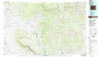
 1968 Montrose1968 Print · USGSThe Western Slope and Continental Divide meet in the late sixties, showing the vital river valleys and high-mountain mining districts. Trace the historic route of the Denver and Rio Grande Western RR or locate small settlements like Sargents and Powderhorn.
 - 1983 Map of Paonia
 1983 Paonia1983 Print · USGSWestern Colorado's North Fork Valley and West Elk high country are shown here in the early eighties as a hub of coal mining and orchard farming. Researchers can trace historic extraction sites like the Colby Mine, rural settlements such as Maher, and landmarks like the Hotchkiss Nat Fish Hatchery.2 unique versions available
End of results
Showing maps 1-8 of 8
Top cities near Somerset
Frequently asked questions
- What are the different types of historical maps available for Somerset?
- What is the oldest map of Somerset?
- Where can I purchase historical maps of Somerset for my home or office?
- Where can I download high-res historical maps of Somerset?
- Are there historical topographic maps available for Somerset?
- Is there historical aerial imagery available for Somerset?
- Where are historical maps of Somerset sourced from?