1940s Maps of Waunita Hot Springs, Colorado
Explore 2 historic maps of Waunita Hot Springs from the 1940s. These maps offer a rare glimpse into what life looked like during the 1940s — showing old roads, neighborhoods, homes, and landmarks that have changed or disappeared over time.
Whether you're researching your family's past, planning a metal detecting trip, or studying how Waunita Hot Springs's landscape evolved across the 1940s, these high-resolution maps are a powerful tool for exploring the history of this region.
- Focus on a specific era: All maps on this page are from the 1940s, giving you a focused view of this time period.
- See what’s changed: Compare century-old streets, trails, and buildings to today's modern landscape using overlays and satellite layers.
- Research with precision: Use these maps for genealogy, historical research, land use analysis, or educational projects.
- View, download, or print: Maps are fully viewable online in high resolution, and can be downloaded or printed for your own records.
Start exploring Waunita Hot Springs's history through authentic maps from the 1940s. This is your window into the past.
Waunita Hot Springs, CO maps
(2)- 1941 Map of Pitkin, 1954 Print
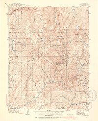 1941 Pitkin1954 Print · USGSGunnison County peaks and high-country mining camps are documented here in the mid-twentieth century. Genealogists and historians can trace families and claims through the Pitkin and Ohio City settlements or locate sites like the Sparta Sch and Gold Links Mine.5 unique versions available
 - 1945 Map of Pitkin
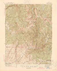 1945 Pitkin1945 Print · USGSGunnison County is shown in high detail during the 1940s, capturing the peak of the region's mining and high-country settlement. Genealogists and historians can trace the foundations of Ohio City, locate the Roosevelt Mine, and find the remote Sparta Sch.2 unique versions available
End of results
Showing maps 1-2 of 2
Top cities near Waunita Hot Springs
Frequently asked questions
- What are the different types of historical maps available for Waunita Hot Springs?
- What is the oldest map of Waunita Hot Springs?
- Where can I purchase historical maps of Waunita Hot Springs for my home or office?
- Where can I download high-res historical maps of Waunita Hot Springs?
- Are there historical topographic maps available for Waunita Hot Springs?
- Is there historical aerial imagery available for Waunita Hot Springs?
- Where are historical maps of Waunita Hot Springs sourced from?