1960s Maps of Arvada, Colorado
Explore 5 historic maps of Arvada from the 1960s. These maps offer a rare glimpse into what life looked like during the 1960s — showing old roads, neighborhoods, homes, and landmarks that have changed or disappeared over time.
Whether you're researching your family's past, planning a metal detecting trip, or studying how Arvada's landscape evolved across the 1960s, these high-resolution maps are a powerful tool for exploring the history of this region.
- Focus on a specific era: All maps on this page are from the 1960s, giving you a focused view of this time period.
- See what’s changed: Compare century-old streets, trails, and buildings to today's modern landscape using overlays and satellite layers.
- Research with precision: Use these maps for genealogy, historical research, land use analysis, or educational projects.
- View, download, or print: Maps are fully viewable online in high resolution, and can be downloaded or printed for your own records.
Start exploring Arvada's history through authentic maps from the 1960s. This is your window into the past.
Arvada, CO maps
(5)- 1960 Map of Denver
 1960 Denver1960 Print · USGSDenver and the Colorado Front Range are seen here at a pivotal moment of postwar expansion into the plains and foothills. Researchers can trace the mid-century rail network of the Denver & Rio Grande Western RR and locate historic institutional landmarks like Buckley Field and the Colorado School of Mines.
 - 1965 Map of Arvada, 1967 Print
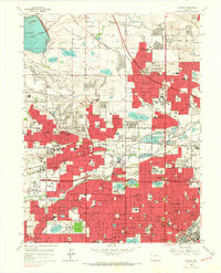 1965 Arvada1967 Print · USGSThe northern Denver suburbs were undergoing a massive post-war expansion in the mid-sixties, filling the spaces between long-standing irrigation canals and rail lines. You can trace the development of local neighborhoods through landmarks like Regis College, Crown Hill Cemetery, and Belleview College.6 unique versions available
 - 1965 Map of Ralston Buttes, 1967 Print
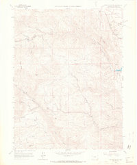 1965 Ralston Buttes1967 Print · USGSJefferson County's foothills in the mid-1960s reveal a landscape of rugged ranching and active mining before the onset of modern development. Researchers can trace the early tracks of the Denver and Rio Grande Western and locate historic sites like Ralston Creek Ranch and Guy Hill.9 unique versions available
 - 1965 Map of Golden, 1967 Print
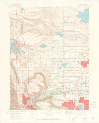 1965 Golden1967 Print · USGSGolden and Arvada appear here during the mid-sixties, caught between their mining roots and rapid suburban growth. Researchers can trace historic sites like Camp George West, the Colorado School of Mines, and the extensive Mount Olivet Cemetery.10 unique versions available
 - 1965 Map of Eldorado Springs, 1967 Print
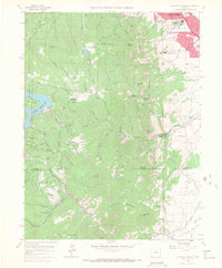 1965 Eldorado Springs1967 Print · USGSThe Front Range foothills come into sharp focus in the mid-sixties, showing the intersection of mountain topography and burgeoning civic infrastructure. Trace the winding Denver and Rio Grande Western rail line through Crescent Village or find family roots near Eldorado Springs and Plainview.8 unique versions available
End of results
Showing maps 1-5 of 5
Top cities near Arvada
- Denver historical maps
- Lakewood historical maps
- Thornton historical maps
- Westminster historical maps
- Boulder historical maps
- Centennial historical maps
See more
Top neighborhoods of Arvada
- Candelas historical maps
- Arvada historical maps
- Arvada Olde Town Square historical maps
- Aspen Point Apartments historical maps
Frequently asked questions
- What are the different types of historical maps available for Arvada?
- What is the oldest map of Arvada?
- Where can I purchase historical maps of Arvada for my home or office?
- Where can I download high-res historical maps of Arvada?
- Are there historical topographic maps available for Arvada?
- Is there historical aerial imagery available for Arvada?
- Where are historical maps of Arvada sourced from?