1900s (20th Century) Maps of Morrison, Colorado
Explore 13 historic maps of Morrison from the 1900s (20th Century). These maps offer a rare glimpse into what life looked like during the 1900s — showing old roads, neighborhoods, homes, and landmarks that have changed or disappeared over time.
Whether you're researching your family's past, planning a metal detecting trip, or studying how Morrison's landscape evolved across the 1900s, these high-resolution maps are a powerful tool for exploring the history of this region.
- Focus on a specific era: All maps on this page are from the 1900s, giving you a focused view of this time period.
- See what’s changed: Compare century-old streets, trails, and buildings to today's modern landscape using overlays and satellite layers.
- Research with precision: Use these maps for genealogy, historical research, land use analysis, or educational projects.
- View, download, or print: Maps are fully viewable online in high resolution, and can be downloaded or printed for your own records.
Start exploring Morrison's history through authentic maps from the 1900s. This is your window into the past.
Morrison, CO maps
(13)- 1938 Map of Morrison
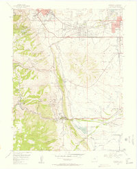
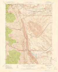 1938 Morrison1938 Print · USGSThe foothills of Jefferson County are shown in the late 1930s as the Front Range began transitioning toward modern recreation and infrastructure. Researchers can locate Red Rocks Park, the State Reformatory, and the Cody Monument on Lookout Mountain.2 unique versions available
 - 1942 Map of Morrison
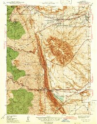 1942 Morrison1942 Print · USGSThe Jefferson County foothills meet the plains during the early 1940s, revealing a landscape of military camps, schools, and landmark parks. Researchers can trace the development of Golden, locate the Pleasant View Ch, and see the early layout of Red Rocks Park.2 unique versions available
 - 1945 Map of Indian Hills
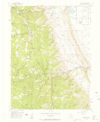
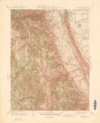 1945 Indian Hills1945 Print · USGSJefferson County foothills life comes into focus in the mid-1940s, showing a landscape of high-altitude ranches and early mountain retreats. Genealogists and hikers can trace old school sites like Medlen Sch and early settlements such as Tiny Town and Phillipsburg.2 unique versions available
 - 1947 Map of Morrison
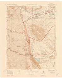 1947 Morrison1947 Print · USGSThe foothills of Jefferson County are captured in the late 1930s, showing the early infrastructure of Golden and Morrison. Genealogists and historians can trace Golden Cemetery, the Pleasant View Ch, and the landmark Cody Monument.2 unique versions available
 - 1953 Map of Denver, 1964 Print
 1953 Denver1964 Print · USGSDenver and the Colorado Front Range are captured here during a decade of post-war growth and military expansion. Researchers can trace the sprawling rail lines of the Union Pacific, locate the State Capitol, and explore historic mountain mining hubs like Central City.6 unique versions available
 - 1957 Map of Denver
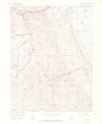
 1957 Denver1957 Print · USGSDenver and the Colorado Front Range are seen here during a mid-century period of intense military and urban expansion. Trace the footprints of the Rocky Mountain Arsenal, the early United States Air Force Academy, and the Lowry AF Base.
 - 1957 Map of Morrison, 1958 Print
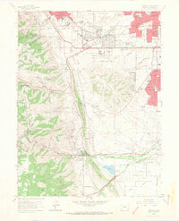
 1957 Morrison1958 Print · USGSThe Denver foothills come alive in the late fifties, showing the interplay between expanding residential areas like Pleasant View and the dramatic geology of the Front Range. Researchers can trace historic sites like the Rooney Ranch, the Mother Cabrini Shrine, and the early layout of Red Rocks Park.
 - 1957 Map of Indian Hills, 1958 Print
 1957 Indian Hills1958 Print · USGSJefferson County’s mountain communities and early ranching history are preserved here during the mid-fifties. Researchers can locate family-named sites like Caryl Ranch, trace the early mountain schoolhouse Sampson Sch, or find the unique settlement of Tiny Town.2 unique versions available
 - 1958 Map of Denver
 1958 Denver1958 Print · USGSDenver and the Colorado Front Range are captured here during the mid-century suburban boom. Trace the footprints of military installations like Buckley Air Force Base alongside the established rail networks of the Colorado & Southern Ry.
 - 1960 Map of Denver
 1960 Denver1960 Print · USGSDenver and the Colorado Front Range are seen here at a pivotal moment of postwar expansion into the plains and foothills. Researchers can trace the mid-century rail network of the Denver & Rio Grande Western RR and locate historic institutional landmarks like Buckley Field and the Colorado School of Mines.
 - 1965 Map of Indian Hills, 1967 Print
 1965 Indian Hills1967 Print · USGSJefferson County mountain life in the mid-sixties is captured here as small communities and ranches follow the winding canyons. Trace local history through family-named landmarks like Ken-Caryl Ranch, the tiny buildings of Tiny Town, and the Sampson Sch.7 unique versions available
 - 1965 Map of Morrison, 1967 Print
 1965 Morrison1967 Print · USGSThe foothills of Jefferson County were rapidly evolving in the mid-sixties as suburban growth met the historic Front Range landscape. Trace local history through landmarks like Red Rocks Amphitheater, the Chieftain Mine, and the Golden Hill Cemetery.6 unique versions available
 - 1983 Map of Denver West
 1983 Denver West1983 Print · USGSThe Front Range and Denver's western suburbs meet in the early 1980s, documenting the era's growth from the mountain peaks to the valley floor. Genealogists and historians can trace the foundations of Lakewood and Golden, or locate high-altitude landmarks like the Moffat Tunnel and Mount Olivet Cem.2 unique versions available
End of results
Showing maps 1-13 of 13
Top cities near Morrison
- Denver historical maps
- Lakewood historical maps
- Thornton historical maps
- Arvada historical maps
- Westminster historical maps
- Highlands Ranch historical maps
See more
Frequently asked questions
- What are the different types of historical maps available for Morrison?
- What is the oldest map of Morrison?
- Where can I purchase historical maps of Morrison for my home or office?
- Where can I download high-res historical maps of Morrison?
- Are there historical topographic maps available for Morrison?
- Is there historical aerial imagery available for Morrison?
- Where are historical maps of Morrison sourced from?