1940s Maps of Morrison, Colorado
Explore 3 historic maps of Morrison from the 1940s. These maps offer a rare glimpse into what life looked like during the 1940s — showing old roads, neighborhoods, homes, and landmarks that have changed or disappeared over time.
Whether you're researching your family's past, planning a metal detecting trip, or studying how Morrison's landscape evolved across the 1940s, these high-resolution maps are a powerful tool for exploring the history of this region.
- Focus on a specific era: All maps on this page are from the 1940s, giving you a focused view of this time period.
- See what’s changed: Compare century-old streets, trails, and buildings to today's modern landscape using overlays and satellite layers.
- Research with precision: Use these maps for genealogy, historical research, land use analysis, or educational projects.
- View, download, or print: Maps are fully viewable online in high resolution, and can be downloaded or printed for your own records.
Start exploring Morrison's history through authentic maps from the 1940s. This is your window into the past.
Morrison, CO maps
(3)- 1942 Map of Morrison
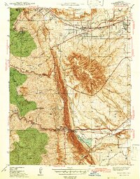 1942 Morrison1942 Print · USGSThe Jefferson County foothills meet the plains during the early 1940s, revealing a landscape of military camps, schools, and landmark parks. Researchers can trace the development of Golden, locate the Pleasant View Ch, and see the early layout of Red Rocks Park.2 unique versions available
 - 1945 Map of Indian Hills
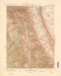 1945 Indian Hills1945 Print · USGSJefferson County foothills life comes into focus in the mid-1940s, showing a landscape of high-altitude ranches and early mountain retreats. Genealogists and hikers can trace old school sites like Medlen Sch and early settlements such as Tiny Town and Phillipsburg.2 unique versions available
 - 1947 Map of Morrison
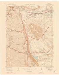 1947 Morrison1947 Print · USGSThe foothills of Jefferson County are captured in the late 1930s, showing the early infrastructure of Golden and Morrison. Genealogists and historians can trace Golden Cemetery, the Pleasant View Ch, and the landmark Cody Monument.2 unique versions available
End of results
Showing maps 1-3 of 3
Top cities near Morrison
- Denver historical maps
- Lakewood historical maps
- Thornton historical maps
- Arvada historical maps
- Westminster historical maps
- Highlands Ranch historical maps
See more
Frequently asked questions
- What are the different types of historical maps available for Morrison?
- What is the oldest map of Morrison?
- Where can I purchase historical maps of Morrison for my home or office?
- Where can I download high-res historical maps of Morrison?
- Are there historical topographic maps available for Morrison?
- Is there historical aerial imagery available for Morrison?
- Where are historical maps of Morrison sourced from?