1940s Maps of South Platte, Colorado
Explore 2 historic maps of South Platte from the 1940s. These maps offer a rare glimpse into what life looked like during the 1940s — showing old roads, neighborhoods, homes, and landmarks that have changed or disappeared over time.
Whether you're researching your family's past, planning a metal detecting trip, or studying how South Platte's landscape evolved across the 1940s, these high-resolution maps are a powerful tool for exploring the history of this region.
- Focus on a specific era: All maps on this page are from the 1940s, giving you a focused view of this time period.
- See what’s changed: Compare century-old streets, trails, and buildings to today's modern landscape using overlays and satellite layers.
- Research with precision: Use these maps for genealogy, historical research, land use analysis, or educational projects.
- View, download, or print: Maps are fully viewable online in high resolution, and can be downloaded or printed for your own records.
Start exploring South Platte's history through authentic maps from the 1940s. This is your window into the past.
South Platte, CO maps
(2)- 1945 Map of Platte Canyon, 1955 Print
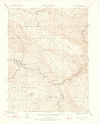 1945 Platte Canyon1955 Print · USGSJefferson and Douglas counties appear here during the mid-1940s, centered on the strategic water gaps of the Front Range. Researchers can trace rural school locations like Lamb Sch and explore small settlements such as Foxton and Longview.2 unique versions available
 - 1948 Map of Platte Canyon
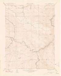 1948 Platte Canyon1948 Print · USGSThe South Platte canyon region in the late 1940s reveals a network of mountain settlements and water infrastructure. Genealogists can locate family sites near South Platte, Foxton, and the Lamb Sch, or trace the winding course of the South Platte River.2 unique versions available
End of results
Showing maps 1-2 of 2
Top cities near South Platte
- Lakewood historical maps
- Highlands Ranch historical maps
- Centennial historical maps
- Littleton historical maps
- Englewood historical maps
- Greenwood Village historical maps
See more
Frequently asked questions
- What are the different types of historical maps available for South Platte?
- What is the oldest map of South Platte?
- Where can I purchase historical maps of South Platte for my home or office?
- Where can I download high-res historical maps of South Platte?
- Are there historical topographic maps available for South Platte?
- Is there historical aerial imagery available for South Platte?
- Where are historical maps of South Platte sourced from?